【题目】跨经度最多的区域是( )
A.北方地区 B.南方地区
C.西北地区 D.青藏地区
 寒假乐园北京教育出版社系列答案
科目:初中地理 来源: 题型:
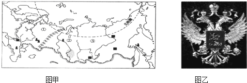
【题目】在俄罗斯的国徽上,最醒目的是双头鹰,它一头望着西方,另一头望着东方,象征着两块大陆间的统一以及各民族的联合,如图为“俄罗斯地形图”和“俄罗斯国徽”.据所学知识回答下列问题.

(1)俄罗斯是一个多民族的国家,主要的民族为 族.
(2)国徽上的双头鹰,一头望着西方,“西方”指 洲,一头望着东方,“东方”指 洲,两大洲的界线a是 山脉.
(3)如果用一个字来形容俄罗斯的地理特征,这个字应该是“平”,说明俄罗斯的地形以 和 为主,读图1填出下列序号所代表的地形区名称.① ,② ,③ .
(4)俄罗斯资源物产丰富,下列商品中,我国最不可能从俄罗斯进口的是 .
A、石油和天然气 B、服装、玩具 C、木材 D、铁矿.
查看答案和解析>>
科目:初中地理 来源: 题型:
【题目】2018年11月25日,第三届博鳌国际旅游传播论坛在海南省琼海市博鳌亚洲论坛大酒店拉开帷幕。本届论坛的主题是
A. 把握包容性机遇,拥抱数字化未来
B. “文化十旅游”的全球智慧与中国路径
C. 新时代,共享未来
D. 打造平等互信、合作共赢的新型安全伙伴关系
查看答案和解析>>
科目:初中地理 来源: 题型:
【题目】
Chinese students are thought to be hard workers who put great effort into their studies. How well do they perform on tests on a world level? The 2018 Program for International Student Assessment (PISA国际学生能力评估项目) found that 15-year-olds in Beijing, Shanghai, Jiangsu and Zhejiang ranked(排列) No 1 in reading, science and math. They got the highest rating(等级) — Level 4.
The PISA is carried out every three years by the Organization for Economic Cooperation and Development (OECD). This year, it tested around 600,000 students in 79 countries and regions.
Students from Singapore came in second place in reading. Students from Macao ranked third in all three categories (类别). Students from the United States ranked Level 3 for reading and science and Level 2 for math.
Chinese mainland students first took part in the PISA in 2009, when students from Shanghai ranked on top. The city's students got the top spot again in 2012.
The PISA rankings have raised global(全球的) interest in Chinese teaching methods. The UK ranked 26th in math in the 2012 PISA. Teachers there are starting to use Chinese math-teaching methods. Around 5,000 of Britain's 16,000 primary schools have used the Shanghai math-teaching method, China Daily reported.
Britain translated math textbooks from Chinese schools and published them in 2017. Every year since 2014, groups of British and Chinese teachers have visited each other's schools to share teaching tips and discuss methods.
The new teaching methods have allowed younger students to learn basic knowledge in a more solid (坚实的) way that makes sure they understand more complex content (复杂的内容) when they are older, noted Carol Knights from Britain's National Centre for Excellence in the Teaching of Math.
Both China and the UK have benefited (获益) from each other. “We've benefited from working with Chinese partners due to(归咎于) the very high quality of lesson planning and teaching for memorization in China. Our Chinese partners have benefited from our methods of the development of character, focus on innovation (创新) and application (应用) of knowledge," Philip Avery, from the Bohunt Education Trust, said to China Daily.
【1】From the article, we know that mainland students ________.
A.won many international prizesB.performed well on the 2018 PISA
C.helped the OECD organize the 2018 PISAD.joined an international student organization
【2】What do we know about the PISA?
A.It tests students from different places.B.It is carried out every year.
C.It is held by the United Nations.D.Its tests cover students in all countries.
【3】What does the report show about students from different regions?
A.Students from Macao ranked second in reading.
B.Students from the US are better at math than reading.
C.15-year-old students from Beijing ranked highest in reading.
D.Students from Shanghai were the best math learners in 2018.
【4】Britain translated math textbooks from Chinese schools to ________.
A.learn how Chinese schools teach math
B.improve British students' ability to innovate
C.help British students apply their knowledge
D.give suggestions to Chinese students who are learning math
【5】What can we infer(推断) from the passage?
A.More countries will pay more attention to their teaching methods.
B.China will get top score again.
C.We should take extra courses after school.
D.The students in China are smarter than those in other countries.
查看答案和解析>>
科目:初中地理 来源: 题型:
【题目】下图是“世界人口增长折线图”。读图,回答下面小题。

【1】世界的人口增长速度
A. 一直很快 B. 18世纪以后开始缓慢
C. 一直缓慢 D. 1930年后迅速加快
【2】人口增长过快可能会带来的问题有
A. 粮食供给压力加大 B. 城市居住条件改善
C. 劳动力能全部就业 D. 消费水平迅速提高
查看答案和解析>>
科目:初中地理 来源: 题型:
【题目】读图,回答下列问题。

(1)图中两国工业发达,甲国A、B、C、D四大工业区建立的共同优势是__________,其中,最大的工业区C为_____________________工业区。乙国最具影响力的高新技术产业园硅谷位于_______________________(城市)。
(2)甲国是世界面积最大的国家,横跨东西的_________________(铁路名称),也称“亚欧大陆桥”,是该国亚洲部分的经济命脉。
(3)两国淡水储量丰富,甲国的母亲河是①____________________,乙国中部平原的水源主要来自河流②__________________________。
查看答案和解析>>
科目:初中地理 来源: 题型:
【题目】A 7-magnitude(震级)earthquake hit Ya'an,Sichuan at 8:02 on April 20, 2013, and it killed at least 196 people and injured more than 11,000.
Together with other students, Yang Xuelan ran out to the playground. She was safe. But all her textbooks and exercise books were buried(埋)in the teaching building.
What can we do when an earthquake happens? In fact, there's little we can do to stop natural disasters (自然灾害) such as earthquakes happening. But, some methods can reduce the harm they cause.

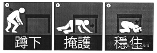
◆ Drop down onto your hands and knees. This way can protect you from falling.
◆ Cover your head under a strong table or desk. You can also stay along a wall,and cover your head with your arms and hands.
◆ Hold on to(守住,抓牢) your shelter(遮蔽物) until the shaking stops. Be prepared to move with your shelter if the shaking continues.
Schools can normally take the earthquake drills(演练) to help student stay alive.
【1】How many people lost their lives in the earthquake in Ya'an?
A. At least 196. B. More than 11,000.
C. Less than 196. D. About 11,196.
【2】When the earthquake happened in Ya'an, Yang Xuelan was .
A. at home B. at school
C. on her way to school D. playing on the playground
【3】What does the underlined word "reduce" mean in Chinese?
A. 提高 B. 阻止 C. 增加 D. 减少
【4】According to the writer, we can to reduce the harm natural disasters cause.
A. do nothing B. stay at home
C. take some methods D. run out of the house
【5】Which of the following can help you stay alive in an earthquake?
A. Dropping down onto your hands and knees.
B. Covering your head under a strong table or desk.
C. Holding on to your shelter until the shaking stops.
D. A, B and C.
查看答案和解析>>
科目:初中地理 来源: 题型:
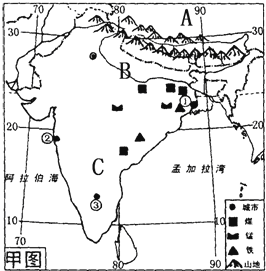
【题目】读印度图,回答下列问题.

(1)A (国家),它和印度之间的山脉是 .
(2)印度地形由南到北分为三大部分,其中北部是山地,中部是由B (河流)冲积形成的平原,该河流在孟加拉国注入 海域),南部是C (地形区),这里主要的粮食作物是 .
(3)该国最主要的自然灾害 ,其原因是 .
(4)根据城市周围的资源条件你推断一下城市①这里可以发展 工业.
(5)近几年印度计算机软件业发展迅速,其产业中心是 (填名称).
查看答案和解析>>
湖北省互联网违法和不良信息举报平台 | 网上有害信息举报专区 | 电信诈骗举报专区 | 涉历史虚无主义有害信息举报专区 | 涉企侵权举报专区
违法和不良信息举报电话:027-86699610 举报邮箱:58377363@163.com