【题目】读图题。(每空1分,共5分)

(1)写出图中字母所表示的地形部位名称:
C.___________ D._______________E__________ _
(2)在这幅图中,最高点的海拔至少在_______米以上。
(3)如果要从A、B两处爬山,则选择从_____处爬山要容易些。
科目:初中地理 来源: 题型:
【题目】【2016山东济宁】阅读下面短文,从每小题 A、B、C、D 四个选项中,选出能回答所提问题或完成所给句子的最佳答案。
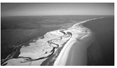
Fraser Island is in Queensland, Australia, about 200 kilometers north of Brisbane. It is about 120 kilometers long and 240 kilometers wide. It is a very important island because it is completely made of sand. In fact, it is the largest sand island in the world. There is no airport on the island, but there is a long beach along the east coast. Planes arrive and leave from here.
The sand makes unusual shapes. There are hills made of sand called sandblows. Nothing grows on them. They move one or two meters a year from the northwest towards the southeast of the island, getting bigger and bigger. At other places on the island, such as Rainbow Gorge, The Cathedrals and Red Canyon, the sandy ro cks have different colors. Sometimes the rocks are so brown that
they turn the sea brown, like coffee.
Surprisingly, the sandy island has a lot of different plants and animals. There are dark forests—eucalyptus woods, beautiful flowers and over a hundred lakes. There are many kinds of birds, like owls and curlews. There are many animals there, too, such as crocodiles, flying foxes and wild dogs called dingoes.
About 500,000 people visit the island every year to see the island's beauty and nature. People enjoy camping and hiking(徒步)there. Unluckily, the visitors create problems. They damage plants and frighten animals. Their sun cream(防晒霜)makes the water dirty. So it is necessary to manage the visitors. For example, people maynot use motor boats or go fishing in the lakes, and they need official papers to drive there.
【1】 The passage is mainly about _______.
A. the shape of Fraser Island
B. nature on Fraser Island
C. the history of Fraser Island
D. daily life on Fraser Island
【2】 From Para.1 we know _______.
A. how large Fraser Island is
B. Fraser Island is the largest island
C. many people live on Fraser Island
D. people will build an airport there
【3】The underlined word "They" in Para. 2 refers to(指)the________.
A. unusual shapes B. sandy hills
C. sandy rocks D. different plants
【4】From the 3rd paragraph we can infer(推断)that ________ is a kind of plant.
A. eucalyptus B. owl
C. curlew D. dingo
【5】 Visitors may not be allowed to _______ on Fraser Island soon.
A. camp and hike
B. go fishing in the sea
C. wear sun cream
D. drive without official papers
查看答案和解析>>
科目:初中地理 来源: 题型:
【题目】读我国“冬、夏季节风向示意图”,分析回答问题。

(1)受海陆位置和纬度位置的影响,我国大多数地区冬、夏季节盛行风向________(填:相同或相反),把这种风向随季节而显著改变的现象称为________气候。
(2)据图可知,我国的降水集中在________(季节),其水汽来源于________洋和________洋。如果夏季风活动不稳定,容易导致的气象灾害是________。
(3)冬季,我国盛行________风和________风;冬季风寒冷干燥,加剧了我国_________地区的严寒,使南北温差加大。四川盆地受冬季风影响________(填:大或小)。
查看答案和解析>>
科目:初中地理 来源: 题型:
【题目】Ⅵ.阅读理解。

A broken brown robot is lying on a beach,while another strong green robot stands on the opposite side of the sea.Everything is so vivid(生动的),including the grass.sand and water.This is not a scene from a movie,but is Wang Yaoli’s Gundam model(高达模型)work called Island Raid.She is a 14 year-old girl from Chongqing Furen High School.The model work won her the Gunpla Builders world Cup 2014,a top Gundam model competition.This year,her model work Hug won third place in the competition.
Wang Yaoli is a super Gundam model and cartoon fan.In primary school,a Gundam model gift from her painting teacher made her fall in love with the models.“It was so cool.I couldn’t help but try it for myself,”she said.Now her room is full of cartoon books and models.
In her eyes,a model is a kind of art rather than just a toy.“It takes patience(耐心),skills and creative ideas,”she said.“It is not simply putting the parts of robots together.You can add parts to show your own creativity.”In her work Hu9,she added an antenna(天线)onto the backpack of the robot.
Wang Yaoli makes models only during summer vacation.“It’s a big project.There are many things to do like assembling(组装)and painting.It takes me one month to make one robot.Sometimes I paint it again and again to make sure that I get the right color,”she said.But she never gets bored.“I love it.In the future,I want to work in the cartoon field and help more people enjoy it,”she said.
【1】We learn from the passage that Island Raid is .
A. a movie’s name B. a brown robot’s name
C. a green robot’s name D. a girl’s Gundam model work
【2】Which of the following about Wang Yaoli is TRUE?
A. She is a l 6-year-old girl.
B. Her work Hug won second place this year.
C. She fell in love with the Gundam models in primary school.
D. Her math teacher once gave her a Gundam model in primary school.
【3】What does Wang Yaoli think of model works?
A. A model is Just a toy for little children.
B. It takes patience,skills and creative ideas to make models.
C. A model is simply putting every part together.
D. It is very boring.
【4】According to the passage,Wang Yaoli .
A. gets bored of making models
B. wants to be a painting teacher in the future
C. plans to work in the cartoon field in the future
D. thinks making models takes too much of her study time
【5】What is the best title for this passage?
A. A girl’s great interest in model works.
B. Gundam model works are popular with young people.
C. An interesting and cool toy.
D. The development of robots.
查看答案和解析>>
科目:初中地理 来源: 题型:
【题目】读下边的经纬网图,按要求填空。(共6 分)

(1)从方向看,B在A的__________方向。
(2)请写出A、B两地的经纬度(先写纬度再写经度)
A(_________ ,_________)1分
B(_________ ,_________)1分
(3)A地位于________(东或西)半球,B地位于_________(北或南)半球。
(4)A地属于纬度带中的_________(低/中/高)纬度带。
查看答案和解析>>
科目:初中地理 来源: 题型:
【题目】读我国局部地区图,回答下列问题。

【1】①处所在地区主要生产的粮食作物是
A.青稞 B.小麦 C.水稻 D.甜菜
【2】下列山脉中南北走向的是
A.秦岭 B.祁连山
C.横断山 D.喜马拉雅山
【3】黄河上游与长江上游共同的水文特征是
A.支流少,水灾频发
B.流量大, 含沙量大
C.河道直,流速快
D.落差大,水力资源丰富
查看答案和解析>>
科目:初中地理 来源: 题型:
【题目】读下图,完成下列两个小题。

【1】关于上图的描述不正确的是( )
A. 两大洲可能曾经是一个整体
B. 南美洲东海岸陆地凸出部分与非洲西海岸陆地凹进部分轮廓比较吻合
C. 海牛和鸵鸟可以在大西洋之间自由游动和飞翔
D. 该发现促进了“大陆漂移学说”的提出
【2】图中海牛和鸵鸟的分布说明了( )
A. 海牛和鸵鸟都会游泳 B. 两块大陆被海洋包围着
C. 两块陆地的形状相似 D. 很久以前两块大陆连在一起
查看答案和解析>>
科目:初中地理 来源: 题型:
【题目】读“板块运动示意图”,回答下列问题。(10分)

(1)板块学说认为,由岩石组成的地球表层并不是整体一块,而是分为__ __大板块。写出图中板块的名称:
A________ _____ D______ _____
E________ _ F_______ _____
(2)字母G附近的日本火山地震 (填多或少),原因是:______ _____。
字母H附近的蒙古火山地震 (填多或少),原因是:______ _____。
(3)喜马拉雅山是亚欧板块和__________板块碰撞挤压而成的。
查看答案和解析>>
科目:初中地理 来源: 题型:
【题目】读我国东部某地等高线示意图(单位:米),回答下列问题(12分)。

(1)地形类型A是 ,地形部位B是 。
(2)山顶D的海拔高度最低不会低于_________米。
(3)图中a.b两条支流水流较急的是 。
(4)疗养院与C点的相对高度为 。
(5)图中A河的流向大致是 。
查看答案和解析>>
湖北省互联网违法和不良信息举报平台 | 网上有害信息举报专区 | 电信诈骗举报专区 | 涉历史虚无主义有害信息举报专区 | 涉企侵权举报专区
违法和不良信息举报电话:027-86699610 举报邮箱:58377363@163.com
