【题目】下列描述中,属于我国北方地区地理环境特征的是( )
A.河湖众多,水网纵横
B.气候湿润,降水充沛
C.以平原为主,年降水量在400-800毫米
D.深居内陆,气候干旱
科目:初中地理 来源: 题型:
【题目】Yuko liked learning about the different planets(行星).She gave a great report in her science class. Along with the report, she showed her classmates a fun activity to help them learn the different patterns of stars. She gave her classmates each a copy of the information so that they could do the activity at home.

【1】When the students have the copy of the information, they can .
A. see the stars in the sky B. enter the school club
C. make the patterns of stars D. buy cheap geography books
【2】The old newspapers .
A. tell you star patterns B. can protect the table
C. are not useful D. are easy to read
【3】In Step 7, students should .
A. fold black paper into stars
B. glue both ends of the tube
C. cut the black paper in pieces
D. tape the paper circle to the tube
【4】A good title for the passage is .
A. Yuko and her classmates B. Planets and stars
C. How to cut paper into stars D. See the stars
查看答案和解析>>
科目:初中地理 来源: 题型:
【题目】关于欧洲西部国家经济的叙述,错误的是
A. 欧洲的经济发展最早,发展水平居各大洲之首
B. 很多国家因地制宜发展有特色的工业部门
C. 农业在本地区中所占比重较小,生产水平较低
D. 农业中种植业和畜牧业结合较好
查看答案和解析>>
科目:初中地理 来源: 题型:
【题目】读图,回答下面小题。

【1】根据图中的信息,你可提出的问题且正确的是
A. 红海面积在不断缩小
B. 阿拉伯半岛气候炎热
C. 阿尔卑斯山海拔在降低
D. 地中海面积在不断缩小
【2】能够解释你所提问题的叙述是
A. 非洲板块与亚欧板块张裂拉伸形成红海
B. 阿拉伯半岛位于板块张裂地带多火山,炎热干旱
C. 亚欧板块与非洲板块张裂使阿尔卑斯山海拔降低
D. 亚欧板块与非洲板块碰撞使地中海面积不断缩小
查看答案和解析>>
科目:初中地理 来源: 题型:
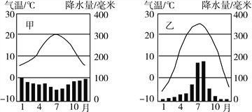
【题目】阅读“气温曲线和降水柱状图”,并按下面的提示完成相关要求。

(1)根据气温曲线图,甲、乙两地气温特点很相似,都是夏季气温较 ,冬季气温较 ,
且最冷月气温均在 ℃以上。
(2)根据降水柱状图,甲、乙两地降水特点有很大的差异,甲地 季多雨,乙地却 季多雨。
查看答案和解析>>
科目:初中地理 来源: 题型:
【题目】2018年6月7日,经党中央批准、国务院批复,自2018年起我国将每年农历秋分设立为“________”节。
A. 中国农民丰收节 B. 中国记者节 C. 中国护士节 D. 中国经济提高节
查看答案和解析>>
科目:初中地理 来源: 题型:
【题目】(2017·绵阳中考)下图为甲、乙两地气候资料。读图完成下列问题。

【1】甲、乙两地中( )
A. 冬季气温甲地低于乙地
B. 年温差甲地小于乙地
C. 甲地降水集中于夏季
D. 乙地降水季节分配均匀
【2】甲、乙两地均位于( )
A. 热带地区 B. 温带地区
C. 寒带地区 D. 高山地区
查看答案和解析>>
湖北省互联网违法和不良信息举报平台 | 网上有害信息举报专区 | 电信诈骗举报专区 | 涉历史虚无主义有害信息举报专区 | 涉企侵权举报专区
违法和不良信息举报电话:027-86699610 举报邮箱:58377363@163.com