【题目】读俄罗斯图,回答下列问题。
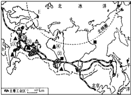
(1)俄罗斯是横跨____两大洲的欧洲国家,首都是____,图中表示俄罗斯首都的字母是_____ 。
(2)写出图中字母代表的地理事物名称。
A _____工业区 ① ______(矿产资源地)② ______工业区
(3)俄罗斯北冰洋沿岸的不冻港是_______ 。(填字母和名称)
科目:初中地理 来源: 题型:
【题目】东非裂谷带被誉为“地球的疤痕”,它是 ( )
A. 世界最大的裂谷带,位于非洲的南部 B. 尼罗河切割东非高原所形成的峡谷
C. 由板块张裂所形成的 D. 撒哈拉沙漠中风力侵蚀作用所形成的风蚀谷
查看答案和解析>>
科目:初中地理 来源: 题型:
【题目】下列关于东南亚的叙述,正确的是 ( )
A. 小麦是主要的粮食作物 B. 物产富饶,大多数国家是发达国家
C. 包括马来半岛和马来群岛两部分 D. 稻米是当地居民的主要粮食
查看答案和解析>>
科目:初中地理 来源: 题型:
【题目】
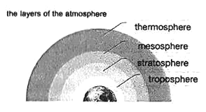
Earth's atmosphere (大气) is made of the layers of air that is around Earth. Thanks to the O2 found in the atmosphere, humans and other animals can breathe.
The atmosphere has four layers. The closest layer to Earth is the troposphere. The troposphere reaches from Earth to about 8 to 15 kilometers above sea level (平面).
It includes most of the air and O2 in the atmosphere, so all life on Earth lives here. The closer to the ground, the warmer the air is. Higher up in the troposphere, the air becomes much colder.
The second layer of the atmosphere is the stratosphere. The stratosphere reaches to around 50 kilometers above Earth. Near the top of the stratosphere is the ozone layer (丑氧层). The ozone layer helps protect life on Earth from the sun's UV radiation. Unluckily, there are holes in several parts of the ozone layer. This could cause serious problems for life on Earth.
The third layer of the atmosphere is the mesosphere. It reaches up to around 80 kilometers above Earth. The mesosphere has the coldest temperature in the atmosphere, It can be as cold as -100℃ there.
The fourth layer is called the thermosphere. It reaches up to around 600 kilometers above Earth. This is where outer space begins. The international space station runs around the planet from this layer. The temperature here is very high. It gets up to 1,200℃.
【1】The troposphere goes up to around ____________ above the Earth.
A. 8-15 kilometersB. 50 kilometersC. 80 kilometersD. 600 kilometers
【2】The ______________ is the coldest layer in the atmosphere.
A. troposphereB. stratosphereC. mesosphereD. themosphere
【3】According to the passage, which of the following statements is TRUE?
A. In the troposphere, the closer to the ground, the colder the air is.
B. The ozone layer could cause problems for life on Earth.
C. Outer space begins from the mesosphere.
D. The temperature in the thermosphere can be 1200℃.
【4】Which of the following shows the structure (结构) of the passage? (P: Paragraph)
A.  B.
B.  C.
C.  D.
D. 
【5】________________ may be the best title of the passage.
A. What Makes up the AtmosphereB. Where Is the Atmosphere
C. The Distance of the AtmosphereD. The Temperature of the Atmosphere
查看答案和解析>>
科目:初中地理 来源: 题型:
【题目】看图做题。

(1)填出图中数字代号所表示的地理事物的名称。
邻国:①_____________,③_____________
隔海相望的国家:④______________⑤______________
岛屿:⑥______________濒临的海:⑧______________。
(2)按五带的划分,我国大部分领土在____带。
查看答案和解析>>
科目:初中地理 来源: 题型:
【题目】“气候”与“天气”既有联系,又有区别。下列描述气候的是( )
A.天空乌云密布,大雨倾盆
B.云南冬无严寒,夏无酷暑
C.今晨寒风凛冽,气温骤降
D.昨日晴空万里,艳阳高照
查看答案和解析>>
科目:初中地理 来源: 题型:
【题目】2019年海峡两岸客货直通航线开通十周年。下图为台湾省示意图。读图,完成下面小题。
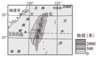
【1】航线的开通促进了台胞回乡寻根探亲,这充分反映台湾和大陆海峡两岸
A. 自然地理环境相同
B. 地质上属同一个大陆板块
C. 经济发展特色相同
D. 社会历史文化渊源深厚
【2】台湾岛盛产热带、亚热带水果,其主要原因是
A. 纬度较低,热量充足
B. 平原为主,种植面积广阔
C. 季风气候,降水季节变化大
D. 河流短小、水能资源丰富
【3】台湾岛水果进入大陆实行零关税政策,反映大陆为台湾经济发展提供了
A. 资金、技术B. 资源、劳动力C. 市场、政策D. 资金、劳动力
查看答案和解析>>
科目:初中地理 来源: 题型:
【题目】读“珠江三角洲地区图”和“澳门示意图”,完成下面小题。

【1】图中④所示的铁路线是 ( )
A. 京广线B. 京九线C. 京沪线D. 深广线
【2】关于香港和澳门地理特征叙述错误的是( )
A. 都是国际金融中心B. 都是自由贸易港
C. 都位于珠江口沿岸 D. 都是地狭人稠
【3】珠江三角洲与港澳经济联系紧密,形成了“前店后厂”的合作模式。在这种合作模式中,珠江三角洲担任的角色是( )
A. “后厂”—产品销售B. “后厂”—产品制造
C. “前店”—产品销售D. “前店”—产品制造
【4】夏季,珠江三角洲容易遭受的极端天气是()
A. 沙尘暴B. 梅雨C. 寒潮D. 台风
查看答案和解析>>
科目:初中地理 来源: 题型:
【题目】读非洲南部地区图和甲乙两幅气候资料图,据图回答下列各题。


【1】甲乙两幅气候资料图,与德班的气候吻合的是( )
A. 甲图B. 乙图C. 两图都是D. 两图都不是
【2】对比甲乙的气候,说法最准确的是( )
A. 气温都是冬冷夏热B. 降水都是冬多夏少
C. 气温年较差相差不大D. 气温年较差相差很大
查看答案和解析>>
湖北省互联网违法和不良信息举报平台 | 网上有害信息举报专区 | 电信诈骗举报专区 | 涉历史虚无主义有害信息举报专区 | 涉企侵权举报专区
违法和不良信息举报电话:027-86699610 举报邮箱:58377363@163.com
