【题目】读“中国气候分布图”和“中国四个城市气候图”,回答下列各题。
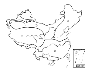
【1】关于气候类型的名称与代码对应正确的是( )
A. 温带季风气候——D——哈尔滨 B. 温带海洋性气候——C——北京
C. 亚热带季风气候——B——武汉 D. 热带雨林气候——A——广州
【2】中国是一个多山的国家,属于E气候类型的山地是( )
A. 武夷山 B. 天山 C. 长白山 D. 大别山
【3】上图中四个城市气候类型相同的是( )
A. 广州和北京 B. 北京和武汉 C. 武汉和哈尔滨 D. 哈尔滨和北京
科目:初中地理 来源: 题型:
【题目】

Bikesharing has swept across China, with an increasing number of people choosing bike riding instead of driving. The bike that the service company provides has GPS or Bluetooth on it, and those bikes can be easily unlocked with a smart phone and left anywhere in public. Bikesharing allows people to borrow a bike from one place and return it at another place easily.
In some cities, we can see more and more people riding this kind of sharingbikes. It's very convenient to use the bikes if you have a smart phone. First, you have to download such an APP on your smart phone. Then what you need to do is to find a nearest bike through the APP, scan the QR code on the bike or connect your phone with the bike over a Bluetooth wireless connection. You will find the bike can be unlocked itself. Then you can enjoy your trip. What's more, the greatest advantage of bikesharing is that you can easily find one and never worry about where to park it. The cost of riding depends on the time that you spend. Normally, every hour you ride, you need to pay one yuan. It doesn't cost so much, does it?
At the same time, some people park the bikes in their own homes. Besides, some people don't value the bikes. Now service companies are trying to solve the problem like being stolen.
Technology and science have changed our social lifestyles. We have to say bikesharing brings us more convenience without doubt. And we also hope that people can not only enjoy it but also put it to good use.
【1】From the first paragraph, we know ________.
A. bikesharing is invented in China
B. sharingbikes are used by some people
C. most people in cities don't drive
D. sharingbikes can be borrowed anywhere
【2】The underlined word “scan” in Paragraph 2 probably means ________ in Chinese.
A. 浏览 B. 扫描 C. 审视 D. 细查
【3】If you want to use a sharingbike, you must ________ first.
A. have a smart phone and download an APP
B. download an APP and pay for the trip
C. unlock the bike and download an APP
D. find a nearest bike and borrow it from anyone
【4】Which of the following is NOT mentioned in this passage?
A. Bikesharing is very cheap.
B. Sharingbikes may be stolen.
C. Sharingbikes are easy to unlock.
D. Bikesharing is a kind of green transport.
【5】The passage probably comes from a ________.
A. science textbook B. tourist guide
C. website news report D. restaurant menu
查看答案和解析>>
科目:初中地理 来源: 题型:
【题目】2013年7月至9月,由中央电视台等多家媒体组织的“感知中国·穿越新丝路——渝新欧国际铁路媒体特别行动”采访团,沿“渝新欧”铁路所经各国采访报道。结合图和表,回答问题。


(1)渝新欧铁路从重庆出发到西安,沿着 线到兰州,然后经过兰新线到达边境口岸阿拉山口,进入 (邻国),再经俄罗斯、白俄罗斯、波兰,至德国的杜伊斯堡,全长11179公里。
(2)采访团从重庆到杜伊斯堡,发现沿途自然景观的变化是森林、温带草原、温带荒漠、温带草原、森林,导致这种景观变化的主要因素是 。
(3)结合表,分析“渝新欧”铁路运输的优点 。
(4)图为伦敦及“渝新欧”铁路沿线三个城市的气候图,据图可知由伦敦到阿斯塔纳降水量的变化特点是 ,气温年较差的变化特点是 。造成这种变化特点的主要因素是 。

(5)重庆有一批货物如果水运到杜伊斯堡,依次经过东海、南海、 海峡(图中甲)、印度洋、红海、 运河(图中乙)、地中海、大西洋到达德国。
查看答案和解析>>
科目:初中地理 来源: 题型:
【题目】2014年7月,金砖五国(巴西、俄罗斯、印度、中国、南非)领导人第五次会晤在巴西首都巴西利亚举行。下表是其中四国的部分资料,阅读并结合所学知识完成下列各题。
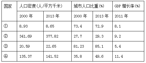
【1】对比四个国家的相关叙述,其中错误的是
A. ①国城市化进程减缓 B. ②国人口增长最慢
C. ③国城市化水平最高 D. ④国经济发展最快
【2】综合各种信息资料判断,表中①②③④代表的国家依次是
A. 俄罗斯、印度、巴西、中国 B. 中国、俄罗斯、印度、巴西
C. 巴西、印度、中国、俄罗斯 D. 印度、巴西、俄罗斯、中国
查看答案和解析>>
科目:初中地理 来源: 题型:
【题目】读下面等高线地形图,完成下面小题。
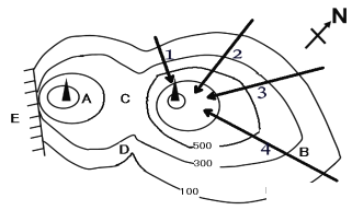
【1】图中表示鞍部的是( )
A. A B. B C. C D. D
【2】上图中,可能出现瀑布的是( )
A. A B. E C. C D. B
【3】上图等高线地形图的等高距是( )
A. 100米 B. 200米 C. 300米 D. 500米
【4】上图1、2、3、4线路,哪条线路到山顶更容易( )
A. 1 B. 2 C. 3 D. 4
【5】图中C在D的什么方向( )
A. 东北 B. 西南
C. 西北 D. 东南
查看答案和解析>>
科目:初中地理 来源: 题型:
【题目】下列甲图中①②两城市地处中纬度沿海地区,乙图是①②两城市的气温曲线和降水柱状图,读图完成下面小题

【1】①②两城市所在的国家共同濒临的大洋是
A. 印度洋 B. 大西洋 C. 太平洋 D. 北冰洋
【2】①②两城市气候相比
A. 高温同期,多雨也同期 B. 高温不同期,多雨同期
C. 高温同期,多雨不同期 D. 高温不同期,多雨也不同期
查看答案和解析>>
科目:初中地理 来源: 题型:
【题目】王林同学绘制了“中国主要气象灾害分布图”,图中甲、乙、丙、丁四图例代表的气象灾害,排列正确的一组是( )

A. 寒潮 洪涝 干旱 台风
B. 台风 干旱 洪涝 寒潮
C. 寒潮 台风 洪涝 干旱
D. 干旱 寒潮 台风 洪涝
查看答案和解析>>
湖北省互联网违法和不良信息举报平台 | 网上有害信息举报专区 | 电信诈骗举报专区 | 涉历史虚无主义有害信息举报专区 | 涉企侵权举报专区
违法和不良信息举报电话:027-86699610 举报邮箱:58377363@163.com
