
【题目】学习区域有妙法,定位、分析、比较是学习区域地理的重要方法。读图,回答下列问题。

(1)写出A、B、C所在的地区:
A________,B________,C________。
(2)分析图中亚库特人的生活习俗与自然环境的关系。(提示:请从位置、气候等方面进行分析)
 状元坊全程突破导练测系列答案
 直通贵州名校周测月考直通名校系列答案
科目:初中地理 来源: 题型:
【题目】读下图,回答问题。
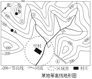
(1)写出图中数字代表的相应地形部位的名称。①____② ____③ ____④_____。
(2)①、②、③、④四地中,适合开展攀岩活动的是_______地。
(3)A地与B地的相对高度约为__________米;同一时间测得A、B两地的气温相比气温更高的______地,大约高_______℃。
(4)乙河干流流向大致是从___向____流,它流经的甲村所在虚线区域内的地形类型是__。
查看答案和解析>>
科目:初中地理 来源: 题型:
【题目】
Chinese students are thought to be hard workers who put great effort into their studies. How well do they perform on tests on a world level? The 2018 Program for International Student Assessment (PISA国际学生能力评估项目) found that 15-year-olds in Beijing, Shanghai, Jiangsu and Zhejiang ranked(排列) No 1 in reading, science and math. They got the highest rating(等级) — Level 4.
The PISA is carried out every three years by the Organization for Economic Cooperation and Development (OECD). This year, it tested around 600,000 students in 79 countries and regions.
Students from Singapore came in second place in reading. Students from Macao ranked third in all three categories (类别). Students from the United States ranked Level 3 for reading and science and Level 2 for math.
Chinese mainland students first took part in the PISA in 2009, when students from Shanghai ranked on top. The city's students got the top spot again in 2012.
The PISA rankings have raised global(全球的) interest in Chinese teaching methods. The UK ranked 26th in math in the 2012 PISA. Teachers there are starting to use Chinese math-teaching methods. Around 5,000 of Britain's 16,000 primary schools have used the Shanghai math-teaching method, China Daily reported.
Britain translated math textbooks from Chinese schools and published them in 2017. Every year since 2014, groups of British and Chinese teachers have visited each other's schools to share teaching tips and discuss methods.
The new teaching methods have allowed younger students to learn basic knowledge in a more solid (坚实的) way that makes sure they understand more complex content (复杂的内容) when they are older, noted Carol Knights from Britain's National Centre for Excellence in the Teaching of Math.
Both China and the UK have benefited (获益) from each other. “We've benefited from working with Chinese partners due to(归咎于) the very high quality of lesson planning and teaching for memorization in China. Our Chinese partners have benefited from our methods of the development of character, focus on innovation (创新) and application (应用) of knowledge," Philip Avery, from the Bohunt Education Trust, said to China Daily.
【1】From the article, we know that mainland students ________.
A.won many international prizesB.performed well on the 2018 PISA
C.helped the OECD organize the 2018 PISAD.joined an international student organization
【2】What do we know about the PISA?
A.It tests students from different places.B.It is carried out every year.
C.It is held by the United Nations.D.Its tests cover students in all countries.
【3】What does the report show about students from different regions?
A.Students from Macao ranked second in reading.
B.Students from the US are better at math than reading.
C.15-year-old students from Beijing ranked highest in reading.
D.Students from Shanghai were the best math learners in 2018.
【4】Britain translated math textbooks from Chinese schools to ________.
A.learn how Chinese schools teach math
B.improve British students' ability to innovate
C.help British students apply their knowledge
D.give suggestions to Chinese students who are learning math
【5】What can we infer(推断) from the passage?
A.More countries will pay more attention to their teaching methods.
B.China will get top score again.
C.We should take extra courses after school.
D.The students in China are smarter than those in other countries.
查看答案和解析>>
科目:初中地理 来源: 题型:
【题目】读图,回答下列问题。

(1)图中两国工业发达,甲国A、B、C、D四大工业区建立的共同优势是__________,其中,最大的工业区C为_____________________工业区。乙国最具影响力的高新技术产业园硅谷位于_______________________(城市)。
(2)甲国是世界面积最大的国家,横跨东西的_________________(铁路名称),也称“亚欧大陆桥”,是该国亚洲部分的经济命脉。
(3)两国淡水储量丰富,甲国的母亲河是①____________________,乙国中部平原的水源主要来自河流②__________________________。
查看答案和解析>>
科目:初中地理 来源: 题型:
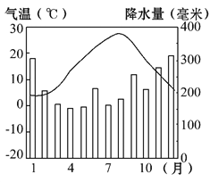
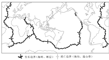
【题目】阅读下面的图文资料,回答以下问题。
材料一 2017年5月28日,日本的鹿儿岛樱岛火山发生大规模喷发。日本地震也频繁发生。
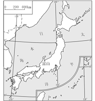
材料二 日本轮廓图、富山多年平均气温和降水量图
材料三 世界六大板块分布图
(1)日本四大岛屿中,面积最大的是_____________。从图上可以看出,日本地形以___________________为主。
(2)富山的气温特点是_______________________________________,_________季降水量最大。说明日本的冬季______________沿岸多雪。
(3)综合气温和降水特点,日本气候的_____________(海洋/大陆)性特征较明显。
(4)日本之所以多火山、地震,原因是地处___________________________________,是___________________火山地震带的一部分。
(5)日本的火山分布区______________众多,形成了一种重要的旅游资源,并深刻影响了生活习俗。
(6)试说出一条日本应对地震的经验
___________________________________________________________。
查看答案和解析>>
科目:初中地理 来源: 题型:
【题目】2022年第24届冬季奥运会将由北京与张家口联合举办,据此完成下列小题。
【1】从气候条件考虑,北京冬奥会最佳的比赛时间是( )
A. 2~3月B. 5~6月C. 8~9月D. 1l~12月
【2】冬奥会的成功申办对北京和张家口两地相关产业的发展有促进作用的是( )
A. 服装产业B. 电子产业C. 基础建设D. 农产品深加工产业
查看答案和解析>>
湖北省互联网违法和不良信息举报平台 | 网上有害信息举报专区 | 电信诈骗举报专区 | 涉历史虚无主义有害信息举报专区 | 涉企侵权举报专区
违法和不良信息举报电话:027-86699610 举报邮箱:58377363@163.com