【题目】金砖国家(中国、俄罗斯、印度、巴西、南非)领导人第九次会晤在我国厦门举行。据图,完成下面小题。

【1】图中四国属于金砖国家的是( )
A.①②B.③④C.①③D.②④
【2】下列说法与图中对应国家相符的是( )
A.①国是世界上面积最大的国家
B.②国分布有世界上最大的热带雨林区
C.③国人口稠密,经济落后
D.④国是世界上唯一独占一块大陆的国家
【3】下列关于四国的首都的说法,正确的是( )
A.都是本国最大的城市B.巴西利亚属热带雨林气候
C.新德里位于德干高原D.当华盛顿寒风刺骨的时候,堪培拉已是骄阳似火
【答案】
【1】D
【2】B
【3】D
【解析】
根据世界各国是指世界上各个国家,截止2015年,世界上共有232个国家和地区,其中国家为197个,地区为35个;从图中看出,①是美国,②是巴西。③是澳大利亚,④是印度,进行分析解答。
【1】①②③④分别是北美洲的美国、南美洲的巴西、独占一个大陆的澳大利亚、南亚的印度。金砖国家是指的中国、俄罗斯、印度、巴西、南非,图中的②巴西和④印度,属于金砖国家。故选:D。
【2】从图中看出,①是美国,②是巴西,③是澳大利亚,④是印度,其中美国领土面积居世界第四位;巴西北部分布有世界上最大的热带雨林区;澳大利亚地广人稀,经济发达,是世界上唯一独占一块大陆的国家。根据题意。故选:B。
【3】巴西首都是巴西利亚,圣保罗是巴西第一大城市,美国的首都是华盛顿,纽约是美国最大的城市,澳大利亚首都是堪培拉,悉尼是全国最大的城市;印度首都是新德里;加尔各答是最大城市,A错误。
巴西利亚属热带草原气候,B错误。
新德里位于恒河平原,C错误。
美国首都华盛顿位于北半球,澳大利亚首都堪培拉位于南半球;南北半球季节相反,当华盛顿寒风刺骨的时候,堪培拉已是骄阳似火,D正确。
故选:D。
本题考查了美国、巴西和澳大利亚、印度的概况。

科目:初中地理 来源: 题型:
【题目】黄河是世界上含沙量最大的河流,治理黄河水患的根本措施是( )
A.在下游加高加固黄河大堤
B.在上游进行水能梯级开发
C.在中游植树造林,搞好水土保持工作
D.在下游多开挖几条入海河道
查看答案和解析>>
科目:初中地理 来源: 题型:
【题目】Jilin is a good place. It is in the north-east of China. On the north of it is Heilongjiang, the south is Liaoning, the west is Inner Mongolia and the east is North Korea(朝鲜).
It has a long and snowy winter. Usually the winter here starts from October and lasts(持续) for six months. Every year people come here for the Ice Lantern Festival and the winter sports.
Changbai Shan is the first mountain in the north-east of China. There is a lot of snow on the main mountain-"Baitou Shan" all the year, so it is named "C. hangbai Shan". It has great forests on it. There are tigers, deer, black bears and many other animals in the forests and there are a lot of hot springs (泉) and more than l,500 kinds of plants. On the very top of the mountain is Tianchi. If you come to the lake, you might see the monster(水怪) in it.
There is also a great waterfall(瀑布) where the Songhua River comes from.
Another place in Jilin is Xianghai in Tongyu County(县). There are more than 100 pieces of wetlands here. And they are of different sizes. There are 170 kinds of birds, some fish that we can't often see and over 250 different herbal(草药) plants and trees here.
【1】Which is the right map?


A. B. C. D.
【2】Winter in Jilin is from _______ to _______.
A. January; April B. September; December C. October; April D. November; May
【3】Which of the following is true?
A. Because of the snow on the top of the main mountain, people named it Changbai Shan.
B. There are tigers, bears and other animals in the hot spring.
C. Tianchi is a lake in the forest at the foot of the mountain.
D. Songhua River comes from the lake of the mountain.
【4】What can we see in the wetland in Tongyu County?
A. Different kinds of birds. B. All kinds of fish. C. Huge monsters. D. North-east tigers.
【5】The writer doesn't tell us _______ in the passage.
A. the neighbors of Jilin B. the temperature in winter in Jilin
C. the famous mountain in Jilin D. where there are herbal plants in Jilin
查看答案和解析>>
科目:初中地理 来源: 题型:
【题目】读“我国某工业地区示意图”,完成下列问题。
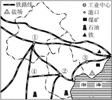
(1)该图展示的是我国_______________工业地区。
(2)图中数字①②③分别代表该工业地区的三个工业中心,①是__________,②是____________,③是___________。
(3)该工业区的工业部门结构特点是我国北方_______________工业基地。
(4)该工业区有丰富的_________、________、_________和__________资源。
(5)该工业区发展工业最便利的交通运输条件是___________运输和_____________运输。
(6)图中数字序号④_______________是纵贯我国南北的主要铁路干线之一。
查看答案和解析>>
科目:初中地理 来源: 题型:
【题目】山东泰山的海拔高度为1 532.7米,安徽黄山的海拔高度是1 864.8米,则两者间的相对高度为( )
A.3397.5米 B.-3 397.5米
C.332.1米 D.-332.1米
查看答案和解析>>
科目:初中地理 来源: 题型:
【题目】关于日本不正确的是( )
A.工业主要分布在濑户内海和太平洋沿岸
B.日本进口最多的矿产资源是煤、石油
C.日本主要的出口产品是工业制成品
D.日本扩大海外投资建厂的主要对象是欧洲、美国、东亚、东南亚
查看答案和解析>>
湖北省互联网违法和不良信息举报平台 | 网上有害信息举报专区 | 电信诈骗举报专区 | 涉历史虚无主义有害信息举报专区 | 涉企侵权举报专区
违法和不良信息举报电话:027-86699610 举报邮箱:58377363@163.com