【题目】“我住江之头,君住江之尾…山山皆向北,条条南流水”,描述的地理特征是( )
A. 九曲回肠,林海雪原 B. 大江东去,千沟万壑
C. 水流平缓,一望无际 D. 山河相间,纵列分布
 阅读快车系列答案
科目:初中地理 来源: 题型:
【题目】读图,完成下列问题。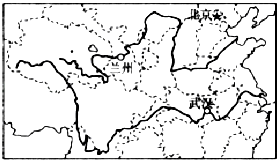
(1)长江和黄河均发源于高原,共同流经的省级行政区是和。
(2)长江和黄河自西向东注入海洋,主要是受我国的影响。
(3)毛泽东主席的“更立西江石壁,截断巫山云雨,高峡出平湖”诗句中的“高峡”指的是 , 如今“高峡出平湖”的设想已变为现实,这就是举世瞩目的水利枢纽工程。
(4)请结合黄河中、下游的特征,谈谈应采取哪些综合治理措施?
查看答案和解析>>
科目:初中地理 来源: 题型:
【题目】读我国“冬、夏季节风向示意图”,分析回答问题。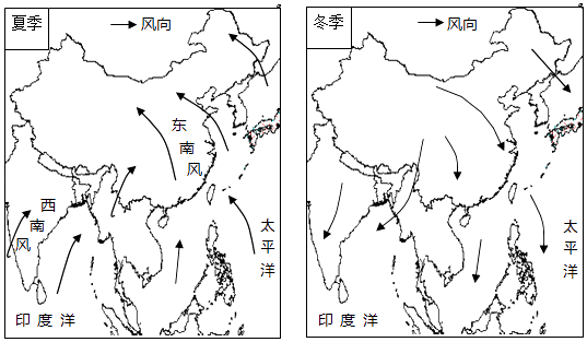
(1)受海陆位置和纬度位置的影响,我国大多数地区冬、夏季节盛行风向(填:相同或相反),把这种风向随季节而显著改变的现象称为气候。
(2)据图可知,我国的降水集中在(季节),其水汽来源于洋和洋。如果夏季风活动不稳定,容易导致的气象灾害是、。
(3)冬季,我国盛行风和风;如果冬季风活动强烈,容易形成(灾害性天气);四川盆地受冬季风影响(填:大或小),主要原因是。
查看答案和解析>>
科目:初中地理 来源: 题型:
【题目】Three Little Kittens

The three little kittens
They lost their mittens and they began to cry
"Oh mother dear we sadly fear
Our mittens we have lost."
"What? Lost your mittens? You naughty kittens!
Then you shall have no pie!"
"Meow meow~"
"Now you shall have no pie!"
The three little kittens
They found their mittens and they began to cry
"Oh mother dear see here see here
Our mittens we have found."
"Put on your mittens you silly kittens.
And you shall have some pie!"
"Meow meow oh, let us have some pie!"
The three little, kittens put on their mittens
And soon ate up the pie
"Oh mother dear we greatly fear .
Our mittens we have soiled."
"Soiled your mittens? You naughty kittens ! "
Then they began to sigh.
Meow Meow
Then they began to sigh
The three little kittens
They washed their mittens and________them out to dry
"Oh mother dear do you not hear
Our mittens we have washed. "
"Washed your mittens? Then you are good kittens.
Let's all have some pie!"
Meow Meow
Let's all have some pie!"
【1】The best word for the blank is_________
A. hungB. hangedC. foundD. lost
【2】What is the song mainly about?
A. Dangerous war.B. Interesting games.
C. Delicious pie.D. Good manners.
查看答案和解析>>
科目:初中地理 来源: 题型:
【题目】
The rockets take astronauts and man-made satellites into space. The satellites are used for communication, weather monitoring and research. But how do satellites stay up without Falling down?
There are two opposite forces acting on the satellite. One of them is the force of gravitation(地心引力), which tries to pull the satellite toward the earth. The other force is created by the rotation (旋转)of the satellite around the earth. This force tries to take the satellite away from the earth. With these two forces, the satellite goes round and round. The gravitational pull of the earth is like a rope which keeps the satellite from flying away.
Everything that goes up has to come down. It is only a matter of time before a satellite comes back to the earth. As time goes by, the satellite loses its speed, which makes the gravitational pull stronger than the force pulling it away. This makes the satellite crash (坠落)down to the earth.
【1】The force that pulls the satellite towards the earth is created by ________.
A. the earthB. the satellite itself
C. the rotation of the satelliteD. the rope
【2】Why can't the satellites fly away?
A. Because of the force from the earth.
B. Because the satellite is too big.
C. Because of the force created by the rotation of the satellite around the earth.
D. Because people on earth have made ropes to tie the satellites tightly.
【3】Which of the following is TRUE according to the passage?
A. There are four forces acting on the satellite.
B. The force of gravitation makes the satellite go round and round.
C. As time goes by, the satellite will finally fall down.
D. The satellite will stay in space forever.
查看答案和解析>>
科目:初中地理 来源: 题型:
【题目】读“长江、黄河示意图”,完成下列各题。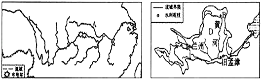
(1)长江、黄河共同发源的地形区是。黄河发源于山脉,长江注入的海域是。
(2)我国长江水系和黄河水系的分水岭是一线。
(3)图中A是长江最大的支流 , B是黄河上、中游的分界点。
(4)D处是黄河中游流经的地形区 , 该区突出的环境问题是。
(5)目前,长江干、支流通航里程达7万千米,货运量占全国内河航运的60%。其自古以来就有“”之称。
(6)黄河是我国的“母亲河”,但历史上水患严重。下列措施中,不能有效治理黄河的是( )
A.加固下游河堤
B.上游地区开荒种地
C.修建水利工程
D.植树种草,加强水土保持。
查看答案和解析>>
科目:初中地理 来源: 题型:
【题目】读下表我国某地区地形类型比例以及土地利用现状图,回答下题。
地形类型 | 占土地面积比例 | 海拔(米) | 鸡食作物 |
平原 | 20% | <200 | 水稻 |
丘陵 | 60% | 200~500 | 水稻、冬小麦 |
中、低山 | 15% | 500~3000 | 春小麦、马铃薯 |
高山 | 5% | >3000 |
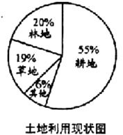
(1)该地区最主要的地形类型是( )
A.平原
B.丘陵
C.中、低山
D.高山
(2)该地区耕地比重过高,容易造成的环境问题是( )
A.土地沙漠化
B.酸雨
C.全球气候变暖
D.水土流失
(3)下列旅游资源位于甘肃省的是( )
A.秦兵马俑
B.敦煌莫高窟
C.乐山大佛
D.华山
查看答案和解析>>
科目:初中地理 来源: 题型:
【题目】读下面的图文材料,回答问题。
材料:中央气象台5月30日06时继续发布高温黄色预警。预计今天白天,河北中南部、北京、天津、黄淮大部、江淮大部、山西中部、宁夏北部、新疆南疆盆地、云南中部、广东中部等地有35℃以上的高温天气。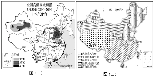
(1)由图(一)可知,我国东部高温区主分布在平原,目前该平原主要的粮食作物(春小麦、冬小麦、水稻)已经进入收获期。
(2)由图(一)、(二)可知,我国四大盆地中的盆地也出现了高温区,它主要位于气候区,该盆地蕴藏着丰富的资源,把该资源运往我国东部地区的工程是。
(3)由图(一)可知,下列省区中,不在高温预警范围内的一组是( )
A.北京、河北
B.西藏、山东
C.河南、新疆
D.江西、福建。
查看答案和解析>>
科目:初中地理 来源: 题型:
【题目】印度是发展中的工农业大国。结合下图,完成下列问题。
(1)填出图中数码所代表的地理事物。
首都:①;河流:②。
(2)印度的主要粮食作物是和。
(3)印度大部分地区每年的6~9月盛行季风,降水较多。
(4)孟买是印度的棉纺织工业中心,其棉纺织工业发展的有利条件有哪些?(从原料、交通等方面分析)
(5)印度人口众多且增长快,会给该国资源和环境带来哪些问题?
查看答案和解析>>
湖北省互联网违法和不良信息举报平台 | 网上有害信息举报专区 | 电信诈骗举报专区 | 涉历史虚无主义有害信息举报专区 | 涉企侵权举报专区
违法和不良信息举报电话:027-86699610 举报邮箱:58377363@163.com
