【题目】“中国龙”﹣﹣﹣黄河哺育了灿烂的中华文明.但其身体上也存在许多“病症”,让我们“把脉”并“对症下药”吧.读黄河图,完成下列问题。

【1】河源地区“大量脱发”的治理措施正确的是
A. 加高堤坝 B.疏浚河道 C.修建梯田 D. 建保护区
【2】河流中游地区“腹泻” 的原因不正确的是
A.降水减少 B.资源开发 C.过度放牧 D.植被破坏
【3】河流下游地区“脚肿” 治理的关键是
A.开挖河道 B.中游治沙 C.加固堤坝 D.修建水库
科目:初中地理 来源: 题型:
【题目】
How do you usually get to school? Do you take a bus or take 36.【1】 subway? Do you go by bike 37. 【2】 by boat?
Shu Tong and her sister 38.【3】 in a small village. There’s a tall mountain 39. 【4】 her village and the school. There is no wide (宽的) road. Every day she has to 40. 【5】 to school with her sister. In the morning they usually 41. 【6】 their home at 6:00. It takes 42. 【7】 a long time to get to school. And when it is rainy or snowy, they can’t go to school. Shu Tong’s 43.【8】 is to have a wide road. And I hope it can 44. 【9】 true soon. What 45. 【10】 you?
查看答案和解析>>
科目:初中地理 来源: 题型:
【题目】读图,回答下列问题。(7分)

(1)写出山脉名称:
A ;B 。
(2)填注海域名称:
C ;D 。
(3)①处所在的温度带是 带。
(4)②地与③地相比,降水较多的是 地,日出时刻较早的是 地。
查看答案和解析>>
科目:初中地理 来源: 题型:
【题目】小宇同学利用A、B两物体、砝码、泡沫等器材探究“压力的作用效果与什么因素有关”的实验。如图所示。
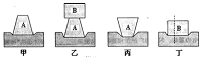
(1)实验中小宇是通过观察 来比较压力作用效果的。
(2)比较甲、乙两图所示实验,能够得到的结论是: 。
(3)若要探究“压力的作用效果与受力面积大小的关系”,应通过比较图 所示实验,此时实验中要控制 不变。
(4)小宇同学实验时将物体B沿竖直方向切成大小不同的两块,如图2-1-38丁所示。他发现它们对泡沫的压力作用效果相同,由此他得出的结论是:压力作用效果与受力面积无关。你认为他在探究过程中存在的问题是 。
查看答案和解析>>
科目:初中地理 来源: 题型:
【题目】读图,请回答下列问题。
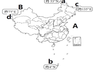
【1】关于我国的地理位置,叙述错误的是 ( )
A.我国的半球位置:东半球和北半球
B.我国的半球位置与俄罗斯相同
C.我国位于中纬度地区
D.我国大部分地区位于寒带,少部分位于温带
【2】关于我国海陆位置的叙述正确的是 ( )
A.我国东临大西洋 B.我国位于亚欧大陆的西部
C.我国是一个岛国 D.我国东部降水丰富
【3】图中a所示的地区为 ( )
A.漠河以北的黑龙江主航道的中心线上
B.南沙群岛的曾母暗沙
C.新疆的帕米尔高原上
D.黑龙江与乌苏里江主航道中心线的相交处
查看答案和解析>>
科目:初中地理 来源: 题型:
【题目】读黄河与长江年径流量图,回答下列问题。

【1】从两幅图中能够直接获取的信息是
A.黄河含沙量比长江大 B.长江的径流量比黄河大得多
C.两条河流都有结冰期 D.黄河的汛期比长江的汛期长
【2】我们把长江誉为“黄金水道”,其主要原因是该河流
A.年径流量大 B.航运价值高
C.水力资源丰富 D.流域内资源丰富
【3】下列长江防洪减灾的措施,错误的是
A.围湖造田 B.加固大堤
C.培育防护林 D.利用洼地修建蓄洪区
查看答案和解析>>
科目:初中地理 来源: 题型:
【题目】(10分)读我国局部政区图,回答下列问题.

(1)省级行政区域的名称:A B
省级行政区域的简称:C D
省级行政区域的行政中心:E F
(2)我国跨经度最广的省级行政区域是 (填字母),其主要的少数民族是 .
查看答案和解析>>
科目:初中地理 来源: 题型:
【题目】长江、黄河是中华民族母亲河。 读下图,完成下列问题。(16分)
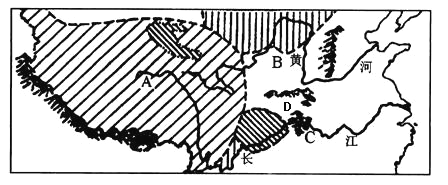
(1)长江、黄河发源地所在的A地形区是 高原。长江、黄河的流向大致为自 向 流,从河流流向可以看出我国地势总特征是 。
(2)图中两条河流,水能丰富、航运价值大,有“水能宝库”、“黄金水道”之称的是 。
(3)图中B地形区是 高原,该地区地表千沟万壑,主要是由于严重的 造成的。使流经该地区的黄河含沙量大,针对该问题应采取的生物措施是 。
(4)长江流域有众多的湖泊,由于围湖造田,湖泊数量锐减,使湖泊调蓄洪水能力 。
(5)新中国成立以来,为了兴利除弊,国家对长江进行了综合治理。重点治理的河段是 和 。
(6)图中C是在长江干流上建成的我国最大水利枢纽—— 水利枢纽。它发挥的综合效益体现在那些方面? 。(任意写出两方面)
(7)图中两河容易发生凌汛的是 ,下游形成地上河的是 。
(8)山脉D为两大河流分水岭,D是 山脉。
查看答案和解析>>
科目:初中地理 来源: 题型:
【题目】阅读理解
A city without cars would be very strange,right?But Venice(威尼斯)is such a city.

Venice is in the northeast of Italy.It wasn’t built on land,like Beijing or Shanghai,but on more than 110 islands.Seawater is everywhere around the city.
Even so,travel isn’t that difficult.The waterways have always been the best way to get around.There are 117 waterways and more than 400 bridges that can lead you where you want to go.
People in Venice move from place to place by boat.They like to enjoy the scenery and cool summer nights while taking boat trips.They can talk to other people as they go along.
Venice grew out of small islands in saltwater lakes when some Italians escaped from a war more than 1,500 years ago,and built homes there.
Water makes the city special,but it is also a big problem.
Once,people used too much underground water.This made the city get lower little by little.Now the city has gone down by 23 centimeters.
Another problem is the rising seawater.The temperature has risen over the years.This has made the ice of Arctic Ocean(北冰洋)melt(融化).
Every year,high waters hit the city in autumn and winter.When a lot of water comes,more than half of the city is underwater.
Scientists are trying different ways to stop the city from getting even lower.
【1】According to the article,which picture shows the right position(位置)of Venice?
A.
B.
C.
D.
【2】Which is the most impossible way for people in Venice to get around in the passage?
A.On foot.
B.By boat.
C.By car.
D.By bike.
【3】Why is Venice still getting lower and lower?
A.Because too many people live there.
B.Because people used too much underground water.
C.Because lots of bridges have been built.
D.Because the underground water is rising.
【4】What seasons are dangerous for Venice because of high waters?
A.Summer and autumn.
B.Autumn and winter.
C.Summer and winter.
D.Spring and winter.
【5】The article is mainly about________.
A.the position of Venice
B.the history of Venice
C.the problem of Venice
D.the scenery of Venice
查看答案和解析>>
湖北省互联网违法和不良信息举报平台 | 网上有害信息举报专区 | 电信诈骗举报专区 | 涉历史虚无主义有害信息举报专区 | 涉企侵权举报专区
违法和不良信息举报电话:027-86699610 举报邮箱:58377363@163.com
