【题目】读我国地理区域示意图,回答下列问题。

(1)我国划分为四大地理区域,图中A____地区最为突出的自然环境特征是_____。
(2)图中C地区有被称为“世界屋脊”的____高原,位于我国地势第_____阶梯上。
(3)图中①是________河,进入华北平原,泥沙大量淤积,导致河床不断抬高,形成举世闻名的“_________”。
(4)图中②是_____盆地,该盆地中有我国面积最大的沙漠。
(5)B和D两地区地理差异明显:耕地类型B地区以旱地为主,D地区以_____为主;主要粮食作物B地区以______为主,D地区以水稻为主。
【答案】西北 干旱 青藏 一级 黄河 地上河 塔里木 水田 小麦
【解析】
根据我国各地的地理环境、自然和人文地理特点的不同,可以将我国划分为四大地理区域.即北方地区、南方地区、西北地区、青藏地区。
(1)从图中可知,A是西北地区,由于西北地区深居内陆,远离海洋,降水少,其自然特征是干旱。
(2)图中C青藏地区有被称为“世界屋脊”的青藏高原(世界海拔最高的高原),位于我国地势第一阶梯上。
(3)根据①河的形状可知,①是黄河,中游流经水土流失严重的黄土高原地区,下游进入华北平原,泥沙大量淤积,导致河床不断抬高,形成举世闻名的“地上河”。
(4)图中②是我国最大的盆地-塔里木盆地,该盆地中有我国面积最大的沙漠-塔克拉玛干沙漠。
(5)图中可知,B是北方地区,D是南方地区,北方地区耕地以旱地为主,南方地区以水田为主;北方地区粮食作物以小麦为主,南方地区以水稻为主。


 口算题天天练系列答案
科目:初中地理 来源: 题型:
【题目】A 7-magnitude(震级)earthquake hit Ya'an,Sichuan at 8:02 on April 20, 2013, and it killed at least 196 people and injured more than 11,000.
Together with other students, Yang Xuelan ran out to the playground. She was safe. But all her textbooks and exercise books were buried(埋)in the teaching building.
What can we do when an earthquake happens? In fact, there's little we can do to stop natural disasters (自然灾害) such as earthquakes happening. But, some methods can reduce the harm they cause.

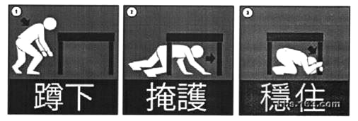
◆ Drop down onto your hands and knees. This way can protect you from falling.
◆ Cover your head under a strong table or desk. You can also stay along a wall,and cover your head with your arms and hands.
◆ Hold on to(守住,抓牢) your shelter(遮蔽物) until the shaking stops. Be prepared to move with your shelter if the shaking continues.
Schools can normally take the earthquake drills(演练) to help student stay alive.
【1】How many people lost their lives in the earthquake in Ya'an?
A. At least 196. B. More than 11,000.
C. Less than 196. D. About 11,196.
【2】When the earthquake happened in Ya'an, Yang Xuelan was .
A. at home B. at school
C. on her way to school D. playing on the playground
【3】What does the underlined word "reduce" mean in Chinese?
A. 提高 B. 阻止 C. 增加 D. 减少
【4】According to the writer, we can to reduce the harm natural disasters cause.
A. do nothing B. stay at home
C. take some methods D. run out of the house
【5】Which of the following can help you stay alive in an earthquake?
A. Dropping down onto your hands and knees.
B. Covering your head under a strong table or desk.
C. Holding on to your shelter until the shaking stops.
D. A, B and C.
查看答案和解析>>
科目:初中地理 来源: 题型:
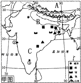
【题目】读印度图,回答下列问题.

(1)A (国家),它和印度之间的山脉是 .
(2)印度地形由南到北分为三大部分,其中北部是山地,中部是由B (河流)冲积形成的平原,该河流在孟加拉国注入 海域),南部是C (地形区),这里主要的粮食作物是 .
(3)该国最主要的自然灾害 ,其原因是 .
(4)根据城市周围的资源条件你推断一下城市①这里可以发展 工业.
(5)近几年印度计算机软件业发展迅速,其产业中心是 (填名称).
查看答案和解析>>
科目:初中地理 来源: 题型:
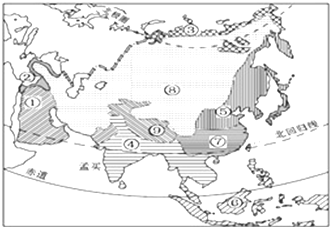
【题目】读亚洲气候类型图,回答下列问题。

(1)亚洲各种气候类型中,序号 ______ 所代表的 ______ 气候类型分布面积最广。
(2)由于亚洲中部 ______ ,形成序号⑨所代表的高原山地气候。
(3)序号⑥所代表的气候类型,其气候特征是 ______
A.炎热干燥 B.全年高温,分旱雨两季
C.高温多雨D.冬暖夏凉.
查看答案和解析>>
湖北省互联网违法和不良信息举报平台 | 网上有害信息举报专区 | 电信诈骗举报专区 | 涉历史虚无主义有害信息举报专区 | 涉企侵权举报专区
违法和不良信息举报电话:027-86699610 举报邮箱:58377363@163.com