【题目】读经纬网图,完成各题
(1)如图为经纬网图,下列叙述正确的是
A.甲、乙两图中,比例尺较大的是图甲
B.A,B均在南半球,西半球
C.B地的经纬度为(23.5°S,126°E)
D.当太阳直射B地时,广州市学生正午的身影一年中最短
(2)图中 A点的位置是( , 60°S),B点的正确位置是( , )
【答案】
(1)D
(2)30°W;12 6°E;23.5°N
【解析】由经线和纬线相互交织所构成的网络叫做经纬网,利用经纬网可以确定地球表面任何一个地点的位置.在经纬网上,经线的度数叫做经度,若相邻两条经线的经度向东增大,就是东经,用符号E表示,若相邻两条经线的经度向西增大,就是西经,用符号W表示;纬线的度数叫纬度,若相邻两条纬线的纬度向北增大,就是北纬,用符号N表示,若相邻两条纬线的纬度向南增大,就是南纬,用符号S表示.读图分析可知:(1)甲乙两图中,甲图所跨的经纬度广,其范围大,比例尺小;A点位于南半球,B点位于北半球;B点的经纬度是23.5°N,126°E;当太阳直射B地即北回归线时,广州市太阳高度最大,其正午影子最短.(2)依据经纬度的判读,图中 A点的位置是30°W,60°S;B点的经纬度位置是126°E,23.5°N.所以答案是:(1)D;(2)30°W;12 6°E;23.5°N.

 红果子三级测试卷系列答案
 课堂练加测系列答案
科目:初中地理 来源: 题型:
【题目】Gareth Ellis, 13, is the youngest son of Alan, an engineer, and Kath, a teacher. His older brothers work in banking and computers, but Gareth's dream was always to become a clown(小丑).Three years ago, Alan, Kath and Gareth joined the circus(马戏团). People laugh when we tell them,' saysKath. 'But it's true. Gareth has wanted to be a clown since we took him to the circus when he was three.'
When Alan lost his job, he and Kath decided to see if they could find full-time circus jobs. They both got jobs with a famous circus and Gareth began training to become a clown. He calls himself Bippo. They travel with the circus during the summer and return home for the winter. Gareth's brothers are old enough to look after the house while they are away.
'I can't say it was easy,' says Kath. 'There was a lot to think about and organize. We only had a car and a very small caravan(大篷车)to sleep in, and we were leaving behind our lovely house. The only thing Gareth missed was his long, hot baths.'
'People ask about my education,' says Gareth, 'but from the beginning, wherever we go, someone has always come to teach me. I follow the same books as everyone back at school and I've got a computer. I've never fallen behind my classmates.'
And the future? 'It was a difficult decision,' says Kath, 'but there was no other way to teach Gareth about being a clown. I'm happy to say it's working, and we're enjoying it.' And Gareth? 'I'm going to be the main clown in a circus one day', he says, 'perhaps Bippo's circus.'
【1】In the article, the writer is trying to .
A. talk about the best way to educate a child B. give details about how to join the circus
C. describe how one family changed their lives D. advise what to do when you lose the job
【2】Alan and Kath joined the circus because .
A. they wanted to spend time travelling in the summer
B. they needed money in order to buy a bigger car
C. their older sons needed their house for themselves
D. their youngest son wanted to train as a performer
【3】When they first join the circus, Kath .
A. found things difficult B. did not have enough to do
C. wanted to go back home D. was not able to sleep properly
【4】Which postcard did Gareth write just after he joined the circus?
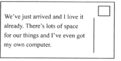
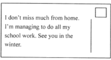
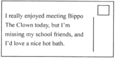
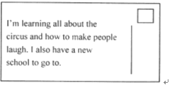
A. B. C. D.
查看答案和解析>>
科目:初中地理 来源: 题型:
【题目】读大洲大洋布图图,回答问题:
(1)写出图中字母代表的大洲名称:
A B DE F G
(2)写出下列字母代表的大洋名称:
a b d
(3)七大洲中,跨经度最广的大洲是 .
查看答案和解析>>
科目:初中地理 来源: 题型:
【题目】粤港澳大湾区是指由广州、深圳、东莞、中山等9市和香港、澳门两个特别行政区组成的城市群。目前,粤港澳大湾区发展已上升为国家战略,其作为中国经济新引擎受到世界瞩目。下表为“粵港澳大湾区部分城市产业对比表”。据此回答下面小题。

【1】粤港澳大湾区中,香港具有的优势产业是
A. 电子信息产业 B. 加工制造业 C. 房地产建筑业 D. 第三产业
【2】多年来,深圳坚持把创新作为引领发展的第一动力,目前正加快全球科技产业创新中心的建设。在深圳产业发展的影响下,东莞、中山的产业变化是
A. 由劳动密集型为主向技术密集型为主转变
B. 由技术密集型为主向劳动密集型为主转变
C. 由农产品加工为主向机械制造业为主转变
D. 由重工业为主向轻工业为主转变
查看答案和解析>>
科目:初中地理 来源: 题型:
【题目】读下列图文材料,回答问题。
材料一 毛里求斯是一个发展中的小国,面积为3020平方千米,人口约120万。过去资金不足,资源匮乏,经济发展缓慢。毛里求斯政府为振兴经济采取了一系列与国情相适应的政策,经济快速发展。从其支柱产业发展来年,20世纪70年代前,以蔗糖业为主;70年代后,形成了以蔗糖业、出口加工业和旅游业为主的三大经济支柱;90年代,在巩固三大支柱产业的基础上,形成以蔗糖业、出口加工业、旅游业和金融服务业为主的四大经济支柱。
材料二 毛里求斯示位置意图、普莱桑斯气温曲线和降水柱状图。

(1)从半球位置看,毛里求斯位于_________半球和_________半球。
(2)请从年降水量、降水季节分配及变化等方面简述普莱桑斯的降水特征。
(3)说明7、8两月,中国游客将毛里求斯作为“避暑胜地”的原因。
(4)近几十年来,毛里求斯经济发展迅速。从毛里求斯支柱产业的变化推测,毛里求斯政府采取了哪些振兴经济的有效措施?
查看答案和解析>>
科目:初中地理 来源: 题型:
【题目】读下列四种气候的气温曲线和降水量柱状图回答下列问题。

(1)A属于_______气候,该气候类型主要分布于_______,其气候特征是_____,主要植被为______。
(2)B气候类型在________洲分布最广,其气候特征是________。
(3)C属于_______气候,该气候类型主要分布于_______。
(4)广布于我国南方地区的D气候类型,其气温和降水的关系是____,该气候分布地区适宜种植的主要粮食作物是______。
查看答案和解析>>
科目:初中地理 来源: 题型:
【题目】读图,完成下列内容
(1)写出下列各点的经、纬度.
A:经度纬度
B:经度纬度
C:经度纬度
(2)A、B、C三点中,位于西半球的是;位于东半球的是 . 位于北半球的是;位于南半球的是 .
(3)A点在B点的方向;C点在B点的方向.
(4)B位于纬度地区(中、低、高)
(5)在图上标出D点(60°E,15°N),E点(120°W,30°S),F点(15°W,15°S).
查看答案和解析>>
湖北省互联网违法和不良信息举报平台 | 网上有害信息举报专区 | 电信诈骗举报专区 | 涉历史虚无主义有害信息举报专区 | 涉企侵权举报专区
违法和不良信息举报电话:027-86699610 举报邮箱:58377363@163.com