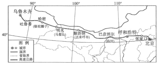
【题目】2017年7月15日,京新高速公路(公路网编号C7)内蒙古段、甘肃段和新疆段三个路段同时通车,标志着北京至新疆更加便捷的公路大通道贯通。读图,回答下面小题。

【1】从北京至乌鲁木齐,沿途拍摄的照片中,排序正确的是

A. ①②③④ B. ①③②④ C. ①②④③ D. ②①③④
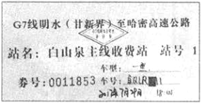
【2】下图是明水收费站的收费凭证,关于明水的叙述正确的是

A. 位于甘蒙交界 B. 此地盛产水稻 C. 此时天气炎热 D. 位于国境线上
【3】京新高速建设过程中,建设者们克服了重重困难。他们面临的困难,可能有
①大面积冻土,施工难度太大 ②途经沙漠戈壁,对外联系不便
③工程线路长,物资供应困难 ④海拔高,工人出现高原反应
A. ①② B. ②③ C. ①④ D. ③④
 天天向上一本好卷系列答案
 小学生10分钟应用题系列答案
科目:初中地理 来源: 题型:
【题目】In the past 200 years,the earth's temperature has increased greatly.It's reported that a marked increase in the temperature of about 0.7℃ appeared at the end of last century.Some scientists think mini-umbrellas(微型伞)might reduce the global(全球的)temperature.
Building a single umbrella,which is big enough to cover the whole earth,seems to be impossible.Roger Angel,a scientist from the USA,has carried out research to deal with this problem.He came up with an idea of mini-umbrellas.In fact,each mini-umbrella is made up of two parts,a spaceship and a sunshade(遮阳篷).A spaceship weighing about 1g would carry a sunshade that is half a meter long.It would be mostly transparent.That means light can pass it directly to reach the earth,with lands and oceans clearly in view.
Pressure(压力)from the sunlight would keep the little spaceships in position around the earth at a distance of about 1.5 million kilometers.As a result,sending over 1,000 billion mini-umbrellas into space would reduce the amount of sunlight reaching the earth.This allows sunlight to be reflected(反射)back to space easily,causing the temperature of the earth's ground to fall off.Covering large areas of the earth,mini-umbrellas together could reflect 1.8 percent of sunlight back.In Roger's plan,scientists will send up 800,000 mini-umbrellas at a time,20 million times in all during ten years.Scientists suggest the earliest launch could be in just 16 years.
Not all the scientists agree with the idea.Some suppose there should be easier and much cheaper ways to prevent the earth from getting too hot,such as to slow down the pollution people bring and to reduce the human activities.Whatever the result of the argument is,this idea of mini-umbrellas in space is certainly creative.
【1】The underlined word“transparent”here probably means “ ”.
A. 透明的 B. 透气的 C. 透风的
【2】Picture shows the right information about the mini-umbrellas.


A. B. C.
【3】After scientists send over 1,000 billion mini-umbrellas into space, .
A. pressure from the sunlight would allow the mini-umbrellas to be reflected back to space easily
B. the mini-umbrellas would reduce the amount of sunlight reaching the earth
C. sunlight would never come into the earth
【4】Which of the following is NOT true according to the passage?
A. Scientists suggest that the earliest launch could be in just 16 years.
B. A spaceship weighing about 1g would carry a sunshade.
C. Roger will send up 800,000 mini-umbrellas into space during 20 years.
【5】The best title for this passage should be .
A. THE TEMPERATURE OF THE EARTH
B. A MINI-UMBRELLA PLAN
C. CHEAPER WAYS TO PREVENT THE POLLUTION
查看答案和解析>>
科目:初中地理 来源: 题型:
【题目】某班同学对中国、美国和俄罗斯三国开展研究性学习,拟定两个研究课题,课题A:“俄美自然地理特征研究”,课题B:“中美经济合作研究”。请根据材料和相关知识,回答下列问题:
材料一 2018年5月17日~18日,中美两国代表团在华盛顿就双边贸易问题进行了建设性磋商并发表联合声明:不打贸易战,停止互相加征关税,两国将继续加强高科技产品和农产品等领域的贸易合作。
材料二 美国和俄罗斯地图。


(1)俄罗斯、美国东西都濒临海洋,两国降水都主要来自_____洋,两国的分界线是______海峡。
(2)伏尔加河是俄罗斯的“母亲河”,注入___海;美国中部的____河是世界第四长河,为农业生产提供了丰富的灌溉水源。
(3)俄罗斯由于纬度较高,大部分地区气候______(特点),因此农业生产受到制约,粮食需要进口;美国农业生产的自然条件十分优越,农业实现了现代化和区域化生产,粮食大量出口,五大湖附近的①__(农业带)形成的社会经济原因是__。
(4)俄罗斯有“天然气王国”之誉,通过___(运输方式)把石油、天然气出口到中国。
(5)美国“硅谷”位于②___(城市)的东南部,这里的每一项重要发明,都会影响到世界电子工业的发展。中国第一个高新技术产业开发区位于北京的_____科技园。
(6)下列叙述错误的是(____)
A.③是棉花带,这里热量充足,是历史上黑色人种奴隶最集中的地区
B.④是贝加尔湖,是世界上最深的淡水湖
C.⑤是海港摩尔曼斯克,终年不冻,原因是受北大西洋暖流的影响
D.⑥是西西伯利亚平原,是俄罗斯重要的农业区
查看答案和解析>>
科目:初中地理 来源: 题型:
【题目】读材料七和黄土高原图,回答问题。
材料七:我国北方大地上,有一片被深厚黄土覆盖的地区,黄土的厚度一般超过100米,并呈现出多种多样的黄土地形景观。
(1)黄土高原的范围:东起西至乌鞘岭,南连 , 北连高原。
(2)黄土高原是世界上最大的堆积区,同时也是最为严重的地区之一。
(3)黄土高原的生态建设,应一方面措施与措施相结合,另一方面,合理安排活动。
查看答案和解析>>
科目:初中地理 来源: 题型:
【题目】读“港澳地区图”,回答问题
(1)B特别行政区,C铁路,临海:D。
(2)香港由香港岛、半岛和三部分及周围200多个岛屿组成;其居民祖籍省最多;澳门由澳门半岛、岛和岛组成。
(3)香港位于祖国东南沿海的东侧,与广东省市经济特区相邻。
(4)港澳地区与珠江三角洲地区经济合作的基本模式为“”。
(5)是香港经济的重要支柱;澳门经济发展的重要支柱产业是。
查看答案和解析>>
科目:初中地理 来源: 题型:
【题目】读两幅图完成下列要求。
(1)对照两幅图,A气候,B是 气候 C是气候 D是候。
(2)赤道附近属于气候。
(3)亚洲大陆东部沿海由南向北分别是气候、气候、气候、气候。
(4)北纬60゜亚欧大陆西部是气候,大陆内部是气候,大陆东部是气候。
(5)A、B、C、D四种气候类型中,属于全年多雨的气候是气候,属于全年少雨的气候是、气候
查看答案和解析>>
科目:初中地理 来源: 题型:
【题目】读“亚欧大陆及非洲部分地区图”,回答下列问题.
(1)欧洲西部是世界上典型的( )气候区。
A.热带雨林
B.温带大陆性
C.温带季风
D.温带海洋性
(2)如图北回归线经过地区中,亚洲和非洲共有的气候类型主要是( )。
A.热带草原气候
B.热带沙漠气候
C.热带季风气候
D.亚热带季风气候
(3)有人说:“非洲是一个高原大陆”.那么,你是如何认识的?
(4)请你根据图中信息,描述亚洲的位置特征.
查看答案和解析>>
湖北省互联网违法和不良信息举报平台 | 网上有害信息举报专区 | 电信诈骗举报专区 | 涉历史虚无主义有害信息举报专区 | 涉企侵权举报专区
违法和不良信息举报电话:027-86699610 举报邮箱:58377363@163.com