【题目】读图填空。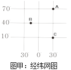
(1)读图甲A点纬度是 , 经度是。
(2)A点在C点的方向。
(3)从南北半球看,B点的半球位置。
(4)在A,B,C三点中,所在纬线圈最长的是。A,B,C三点中高纬度的是(填字母)。
(5)该点离赤道最近读图乙地球某时刻光照示意图,完成下题。
地球自转的方向是 , 自转周期。地球自转产生地理现象。
【答案】
(1)70°N,30°E
(2)正北
(3)北半球
(4)C,A
(5)自西向东,一天,昼夜交替和时间差异
【解析】本题考查经纬网地图及地球自转的相关知识,读图理解解答即可。
(1)人们把赤道定为0度纬线,向南向北各分为90度,在赤道以南的叫南纬(S),度数向南越来越大;在赤道以北的叫北纬(N),度数向北越来越大;人们把本初子午线定为0度经线,向东向西各分为180度,在0度经线以东的叫东经(E),度数向东越来越大;在0度经线以西的叫西经(W),度数向西越来越大。读图分析可知,图中A点的纬度是70°N,经度是30°E。
(2)根据纬线指示东西方向,经线指示南北方向可以判断,图中A点在C点的正北方向。
(3)南北半球的分界线是赤道,赤道以北是北半球,以南是南半球。读图可知,B点在赤道以北,所以在北半球。
(4)纬线的长度的分布特点为赤道最长,向两极渐短成一点。读图可知,图中A、B、C三点中,C点离赤道最近,所在的纬线圈最长。0度~30度为低纬度地区,30度~60度为中纬度地区,60度~90度为高纬度地区,读图分析可知,图中A在高纬度,B在高纬度,C在低纬度。
(5)地球绕地轴不停转动,叫地球自转。地球自转的方向是自西向东,自转的周期是一天。地球自转产生的地理现象是昼夜交替和时间差异。
所以答案是:(1)70°N;30°E;(2)正北;(3)北;(4)C;;A;(5)自西向东;一天;昼夜交替和时间差异。

科目:初中地理 来源: 题型:
【题目】读“长江三角洲地区略图”、“长江三角洲地区地理位置示意图”,回答下列问题。
(1)长江三角洲城市群的核心城市是(填图中字母);图为数码①代表的铁路线名称是。
(2)该地区发展了水稻种植和淡水养殖,符合发展农业要“”的原则,城郊地区积极发展菜、肉、蛋、奶等生产,主要考虑的社会经济条件是 , 下列食材中(莲藕、椰子、竹笋),主要分布在该地区的是。
(3)长江三角洲地区旖旎的水乡风光和深厚的历史积淀,吸引着国内外游客前来观光旅游。假如你是一名导游,请你向游客推荐一处世界文化遗产景区,一处水乡景点:、。
(4)请根据长江三角洲地区地理位置示意图,说明该地区地理位置的特点。
(5)本区是我国著名的“鱼米之乡”,试分析该区域纬度位置和海陆位置对“鱼米之乡”的形成有何影响?
查看答案和解析>>
科目:初中地理 来源: 题型:
【题目】读图,完成下列问题。
(1)长江和黄河均发源于高原,共同流经的省级行政区是和。
(2)长江和黄河自西向东注入海洋,主要是受我国的影响。
(3)毛泽东主席的“更立西江石壁,截断巫山云雨,高峡出平湖”诗句中的“高峡”指的是 , 如今“高峡出平湖”的设想已变为现实,这就是举世瞩目的水利枢纽工程。
(4)请结合黄河中、下游的特征,谈谈应采取哪些综合治理措施?
查看答案和解析>>
科目:初中地理 来源: 题型:
【题目】读图,完成下题。
(1)海口的经纬度位置大致是( )
A.20°N,120°W
B.20°S,120°E
C.20°N,110°E
D.20°S,120°W
(2)杭州在台北的( )
A.东南方向
B.西南方向
C.东北方向
D.西北方向
(3)字母S处是( )
A.琼州海峡
B.台湾海峡
C.马六甲海峡
D.直布罗陀海峡
查看答案和解析>>
科目:初中地理 来源: 题型:
【题目】读图完成以下问题
(1)山脉A是 , 其南侧的地形区是。
(2)山脉B是 , 它位于我国第、级阶梯的分界线上。
(3)山脉E东、西两侧的地形区分别是、。
(4)山脉D的东侧的地形区是。
(5)F是山脉,呈走向。
查看答案和解析>>
科目:初中地理 来源: 题型:
【题目】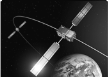
The rockets take astronauts and man-made satellites into space. The satellites are used for communication, weather monitoring and research. But how do satellites stay up without Falling down?
There are two opposite forces acting on the satellite. One of them is the force of gravitation(地心引力), which tries to pull the satellite toward the earth. The other force is created by the rotation (旋转)of the satellite around the earth. This force tries to take the satellite away from the earth. With these two forces, the satellite goes round and round. The gravitational pull of the earth is like a rope which keeps the satellite from flying away.
Everything that goes up has to come down. It is only a matter of time before a satellite comes back to the earth. As time goes by, the satellite loses its speed, which makes the gravitational pull stronger than the force pulling it away. This makes the satellite crash (坠落)down to the earth.
【1】The force that pulls the satellite towards the earth is created by ________.
A. the earthB. the satellite itself
C. the rotation of the satelliteD. the rope
【2】Why can't the satellites fly away?
A. Because of the force from the earth.
B. Because the satellite is too big.
C. Because of the force created by the rotation of the satellite around the earth.
D. Because people on earth have made ropes to tie the satellites tightly.
【3】Which of the following is TRUE according to the passage?
A. There are four forces acting on the satellite.
B. The force of gravitation makes the satellite go round and round.
C. As time goes by, the satellite will finally fall down.
D. The satellite will stay in space forever.
查看答案和解析>>
湖北省互联网违法和不良信息举报平台 | 网上有害信息举报专区 | 电信诈骗举报专区 | 涉历史虚无主义有害信息举报专区 | 涉企侵权举报专区
违法和不良信息举报电话:027-86699610 举报邮箱:58377363@163.com