【题目】有关世界年降水量分布的说法正确的是( )
A.沿海地区降水一定十分充沛,内陆地区降水一定十分稀少
B.世界各地都是夏季降水多,冬季降水少
C.南北回归线附近的大陆东岸降水少,西岸降水多
D.一般而言,赤道地区降水多,两极地区降水少
 各地期末复习特训卷系列答案
 小博士期末闯关100分系列答案
科目:初中地理 来源: 题型:
【题目】关于黄土高原水土流失严重的根本原因,叙述错误的是( )
A. 地表光秃裸露,植被稀少 B. 降水集中在7、8月份,多暴雨
C. 黄土土质疏松、易溶 D. 地震、泥石流灾害日益频繁
查看答案和解析>>
科目:初中地理 来源: 题型:
【题目】Jilin is a good place. It is in the north-east of China. On the north of it is Heilongjiang, the south is Liaoning, the west is Inner Mongolia and the east is North Korea(朝鲜).
It has a long and snowy winter. Usually the winter here starts from October and lasts(持续) for six months. Every year people come here for the Ice Lantern Festival and the winter sports.
Changbai Shan is the first mountain in the north-east of China. There is a lot of snow on the main mountain-"Baitou Shan" all the year, so it is named "C. hangbai Shan". It has great forests on it. There are tigers, deer, black bears and many other animals in the forests and there are a lot of hot springs (泉) and more than l,500 kinds of plants. On the very top of the mountain is Tianchi. If you come to the lake, you might see the monster(水怪) in it.
There is also a great waterfall(瀑布) where the Songhua River comes from.
Another place in Jilin is Xianghai in Tongyu County(县). There are more than 100 pieces of wetlands here. And they are of different sizes. There are 170 kinds of birds, some fish that we can't often see and over 250 different herbal(草药) plants and trees here.
【1】Which is the right map?
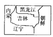
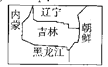
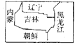
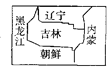
A. B. C. D.
【2】Winter in Jilin is from _______ to _______.
A. January; April B. September; December C. October; April D. November; May
【3】Which of the following is true?
A. Because of the snow on the top of the main mountain, people named it Changbai Shan.
B. There are tigers, bears and other animals in the hot spring.
C. Tianchi is a lake in the forest at the foot of the mountain.
D. Songhua River comes from the lake of the mountain.
【4】What can we see in the wetland in Tongyu County?
A. Different kinds of birds. B. All kinds of fish. C. Huge monsters. D. North-east tigers.
【5】The writer doesn't tell us _______ in the passage.
A. the neighbors of Jilin B. the temperature in winter in Jilin
C. the famous mountain in Jilin D. where there are herbal plants in Jilin
查看答案和解析>>
科目:初中地理 来源: 题型:
【题目】读“我国某工业地区示意图”,完成下列问题。
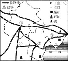
(1)该图展示的是我国_______________工业地区。
(2)图中数字①②③分别代表该工业地区的三个工业中心,①是__________,②是____________,③是___________。
(3)该工业区的工业部门结构特点是我国北方_______________工业基地。
(4)该工业区有丰富的_________、________、_________和__________资源。
(5)该工业区发展工业最便利的交通运输条件是___________运输和_____________运输。
(6)图中数字序号④_______________是纵贯我国南北的主要铁路干线之一。
查看答案和解析>>
科目:初中地理 来源: 题型:
【题目】山东泰山的海拔高度为1 532.7米,安徽黄山的海拔高度是1 864.8米,则两者间的相对高度为( )
A.3397.5米 B.-3 397.5米
C.332.1米 D.-332.1米
查看答案和解析>>
科目:初中地理 来源: 题型:
【题目】甲、乙两人以相同速度从南极同时出发,分别沿40°E和40°W向北前进,可能发生的情况是( )
A. 他们在北极相遇 B. 在赤道上他们之间相距最近
C. 他们之间的距离始终不变 D. 他们可能在南极再相会
查看答案和解析>>
科目:初中地理 来源: 题型:
【题目】读部分省区图,完成下面小题。
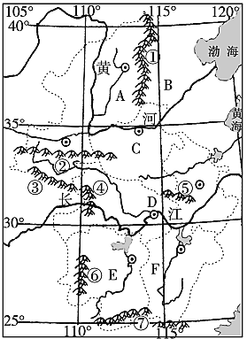
【1】在字母A-F所在地的6个省区中,省会为太原、简称为湘,其组合正确的一组是
A.河北、河南B.湖北、湖南C.山西、江西D.山西、湖南
【2】图中关于A、B、D、E所在地的地形区名称对应正确的是
A.华北平原、黄土高原、江南丘陵、长江中下游平原
B.内蒙古高原、华北平原、江南丘陵、长江中下游平原
C.内蒙古高原、黄土高原、长江中下游平原、江南丘陵
D.黄土高原、华北平原、长江中下游平原、江南丘陵
【3】图中山脉①一⑦中,属于我国阶梯界线的一组是
A.①②④B.②④⑥C.①④⑥D.④⑥⑦
【4】图中A所在地的地形区水土流失严重,其产生的人为原因主要是
A.过度垦殖B.人类活动排放废气C.城市化D.全球气候变暖
【5】图中D地区河湖酸化严重,为了解决该问题采取的最合理措施是
A.减少鱼类养殖,增加水稻种植B.降低三峡水位,增加河流流量
C.节能减排,使用清洁能源D.桔杆还田,少使用化肥
【6】下列有关对图示地区的说法,正确的是
A.A地区传统民居有窑洞B.B地区传统民居有竹楼
C.C地区有赛龙舟活动D.E地区冬季有滑雪比赛
查看答案和解析>>
湖北省互联网违法和不良信息举报平台 | 网上有害信息举报专区 | 电信诈骗举报专区 | 涉历史虚无主义有害信息举报专区 | 涉企侵权举报专区
违法和不良信息举报电话:027-86699610 举报邮箱:58377363@163.com
