科目: 来源: 题型:
【题目】读“黄河水系图”,完成下列问题。(15分)

(1)黄河发源于青藏高原上的 山脉,受我国地势特征的影响,流向大致流,最终注入 。
(2)图中黄河的两条大的支流名称E ,D ;
(3)黄河沿岸有若干重要的城市,其中② ,③ ;
(4)C 水利枢纽是黄河上重要的大型水利枢纽工程。
(5)“跳进黄河也洗不清”,这句话从地理角度分析主要因为黄河流经了 后, (水文特征),所以河水浑浊。所以想要解决该问题的根本措施是 ;
(6)黄河下游存在的忧患是 和 ;请你就黄河下游存在的任一个忧患提出两点有效措施 ; 。
查看答案和解析>>
科目: 来源: 题型:
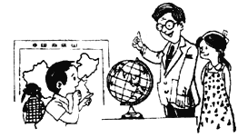
【题目】地球仪和地图是学习地理的工具,是地理信息的载体。在教室里,有的同学在看地图,有的同学就有关地球和地图的知识向老师请教。据此并依照下图回答有关问题。(5分)

(1)看地图的同学,观察的是( )
A.法国地形图
B.俄罗斯矿产图
C.中国政区图
D.美国交通图
(2)地球仪上可以画出多少条纬线和经线? _______
(3)在地球仪上,可以“坐地日行八万里”的纬线是__________________。
(4)地球的自转方向是_____________,在北极上空观察地球的自转应是___________时针方向。
查看答案和解析>>
科目: 来源: 题型:
【题目】读“大洲和大洋的分布图”,完成下列各题。

【1】①、②两大洲的大陆是一个整体,合称为( )
A.非洲大陆 B.美洲大陆
C.亚欧大陆 D.南极大陆
【2】关于全球海陆分布的叙述,正确的是( )
A.全球海陆所占比例可以概括为“三分海洋,七分陆地”
B.陆地的分布南半球比北半球多,海洋的分布北半球比南半球多
C.北半球陆地面积大于海洋,南半球海洋面积大于陆地
D.无论是南、北半球还是东、西半球,都是海洋面积大于陆地
查看答案和解析>>
科目: 来源: 题型:
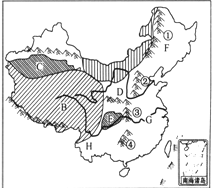
【题目】读下图,完成下列要求。

(1)山脉①是________________;
(2)地形区D 是______________高原;
(3)山脉③西侧地形区E的气候类型是 。
(4)地形区B位于我国第__________阶梯。
(5)F地区的农作物熟制为______________。
查看答案和解析>>
科目: 来源: 题型:
【题目】任务型阅读
Street Markets Around the World
There are many ways of shopping.You can shop by telephone,by post or through your home computer,but for many people,the most exciting way to shop is also the most traditional—at a street market.You can find markets anywhere in the world.Here are four of them:
There are many“floating markets”in Asia;perhaps the most unusual is in Thailand,at a place called Damnoen Saduak.It’s open from six in the morning to the noon every day.People sell fresh fruit from their boats.
|
Many Belgians(比利时人)say that the Grand Place is the most beautiful square in the world.It is the home of a colorful flower market.It’s open every day except Monday.On Monday,instead of flowers,there’s a wonderful bird market!
|
One of the world’s most famous markets is in Mexico City—the Sonora Market.You can buy toys,birds,herbs and medicine.There are all kinds of things.It’s open every day from early in the morning till late at night.
|
In England,every weekend,thousands of young people from all over London travel to the Camden Market—it’s the place to go for street fashion,CDs and tapes.Many people also go there for fun.
|
根据短文内容,在表格中的横线上填写所缺单词。每空一词。
Names | Countries | Features | Things to Sell | Open Time |
Damnoen Saduak | Thailand | unusual | fresh (1)________ | every day |
the Grand Place | Belgium(比利时) | beautiful | (2)________ | every day except Monday |
the Sonora Market | Mexico | (3)________ | all kinds of things | every day |
the Camden Market | (4)________ | fashionable | fashion things | every (5)________ |
查看答案和解析>>
科目: 来源: 题型:
【题目】读六大板块图回答问题。(5分)

(1)写板块名称:①_____________③___________。(2分)
(2)喜马拉雅山位于______板块与______板块交界处。(2分)
(3)我国台湾省多地震,主要是因为地处世界两大地震带之一的 。(1分)
查看答案和解析>>
科目: 来源: 题型:
【题目】阅读理解
A city without cars would be very strange,right?But Venice(威尼斯)is such a city.

Venice is in the northeast of Italy.It wasn’t built on land,like Beijing or Shanghai,but on more than 110 islands.Seawater is everywhere around the city.
Even so,travel isn’t that difficult.The waterways have always been the best way to get around.There are 117 waterways and more than 400 bridges that can lead you where you want to go.
People in Venice move from place to place by boat.They like to enjoy the scenery and cool summer nights while taking boat trips.They can talk to other people as they go along.
Venice grew out of small islands in saltwater lakes when some Italians escaped from a war more than 1,500 years ago,and built homes there.
Water makes the city special,but it is also a big problem.
Once,people used too much underground water.This made the city get lower little by little.Now the city has gone down by 23 centimeters.
Another problem is the rising seawater.The temperature has risen over the years.This has made the ice of Arctic Ocean(北冰洋)melt(融化).
Every year,high waters hit the city in autumn and winter.When a lot of water comes,more than half of the city is underwater.
Scientists are trying different ways to stop the city from getting even lower.
【1】According to the article,which picture shows the right position(位置)of Venice?
A.
B.
C.
D.
【2】Which is the most impossible way for people in Venice to get around in the passage?
A.On foot.
B.By boat.
C.By car.
D.By bike.
【3】Why is Venice still getting lower and lower?
A.Because too many people live there.
B.Because people used too much underground water.
C.Because lots of bridges have been built.
D.Because the underground water is rising.
【4】What seasons are dangerous for Venice because of high waters?
A.Summer and autumn.
B.Autumn and winter.
C.Summer and winter.
D.Spring and winter.
【5】The article is mainly about________.
A.the position of Venice
B.the history of Venice
C.the problem of Venice
D.the scenery of Venice
查看答案和解析>>
科目: 来源: 题型:
【题目】读我国行政区划图和我国疆域图,完成下列问题。

【1】关于左图-我国行政区划图中四个省区的叙述,正确的是( )
A.①省是我国分布民族最多的省级行政区
B.②省区地形以高原为主,它只和蒙古国为邻
C.③省区是我国平均海拔最高的省区,是长江、黄河的发源地
D.④省简称“辽”是我国分布纬度最高的省区
【2】读右图-我国疆域图,对我国的位置评价,不正确的是( )
A.南北跨纬度广,气候差异大,为我国发展多种农业经济提供了有利条件
B.辽阔的海域,便于我国海洋事业和国际贸易的发展
C.陆地疆域深入亚欧大陆内部,便于我国与众多陆上邻国发展边境贸易
D.我国领土全部位于北温带,温和多雨,利于农业生产
查看答案和解析>>
科目: 来源: 题型:
【题目】读《五带划分图》回答问题。(8分)

(1)写出图中字母所处的热量带名称:
A_____________、 B_____________、C_____________
(2)写出图中数码的纬线度数及符号.
①________________ ②________________ ③________________
(3)有极昼极夜现象的是____有阳光直射现象的是________。(用字母填写)
查看答案和解析>>
科目: 来源: 题型:
【题目】读下图“某地等高线地形图”,回答下列问题:(8分)

(1)写出图中字母所在部位的地形名称:
A ________B ________C ________ D ________ 。
(2)山顶甲与山顶乙的相对高度是________米。
(3)如果甲、乙两个山顶的图上距离为3厘米,那么它们的实地距离为________米。
(4)山顶甲在山顶乙的________方向。
(5)图中小河E的流向是________________。
查看答案和解析>>
湖北省互联网违法和不良信息举报平台 | 网上有害信息举报专区 | 电信诈骗举报专区 | 涉历史虚无主义有害信息举报专区 | 涉企侵权举报专区
违法和不良信息举报电话:027-86699610 举报邮箱:58377363@163.com