科目: 来源: 题型:
【题目】读“世界海陆分布略图”,完成下列各题。
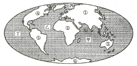
(1)地球表面分为海洋和陆地,海洋面积约占____%。海洋彼此相通。
(2)按要求填写地理事物名称:
在图中六个大陆中,不与其他大陆相连的是____(代号)—— (名称)、____(代号)—— (名称)。跨经度最广的大陆是 。
①大陆分属____洲和____洲,这两个大洲的陆上分界线是____山、乌拉尔河、____ 山。
图中甲、乙、丙、丁表示大洋,其中面积最小的大洋是____(代号)—— (名称),形状似“S”的大洋是____(代号)——____(代号)。
(3)描述⑤大陆的海陆位置。
查看答案和解析>>
科目: 来源: 题型:
【题目】读大洲、大洋图回答下列问题:
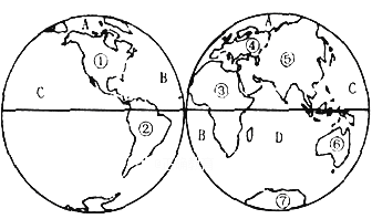
(1)请写出图中数字所代表的大洲名称:
、③ 、④ 。
(2)请写出图中字母所代表的大洋名称:
B 、C 、D 。
(3)①、②大洲之间的分界线是 运河,③、⑤大洲之间的分界线是 运河。
(4)绝大部分位于寒带的大洲是 洲。
查看答案和解析>>
科目: 来源: 题型:
【题目】

Bikesharing has swept across China, with an increasing number of people choosing bike riding instead of driving. The bike that the service company provides has GPS or Bluetooth on it, and those bikes can be easily unlocked with a smart phone and left anywhere in public. Bikesharing allows people to borrow a bike from one place and return it at another place easily.
In some cities, we can see more and more people riding this kind of sharingbikes. It's very convenient to use the bikes if you have a smart phone. First, you have to download such an APP on your smart phone. Then what you need to do is to find a nearest bike through the APP, scan the QR code on the bike or connect your phone with the bike over a Bluetooth wireless connection. You will find the bike can be unlocked itself. Then you can enjoy your trip. What's more, the greatest advantage of bikesharing is that you can easily find one and never worry about where to park it. The cost of riding depends on the time that you spend. Normally, every hour you ride, you need to pay one yuan. It doesn't cost so much, does it?
At the same time, some people park the bikes in their own homes. Besides, some people don't value the bikes. Now service companies are trying to solve the problem like being stolen.
Technology and science have changed our social lifestyles. We have to say bikesharing brings us more convenience without doubt. And we also hope that people can not only enjoy it but also put it to good use.
【1】From the first paragraph, we know ________.
A. bikesharing is invented in China
B. sharingbikes are used by some people
C. most people in cities don't drive
D. sharingbikes can be borrowed anywhere
【2】The underlined word “scan” in Paragraph 2 probably means ________ in Chinese.
A. 浏览 B. 扫描 C. 审视 D. 细查
【3】If you want to use a sharingbike, you must ________ first.
A. have a smart phone and download an APP
B. download an APP and pay for the trip
C. unlock the bike and download an APP
D. find a nearest bike and borrow it from anyone
【4】Which of the following is NOT mentioned in this passage?
A. Bikesharing is very cheap.
B. Sharingbikes may be stolen.
C. Sharingbikes are easy to unlock.
D. Bikesharing is a kind of green transport.
【5】The passage probably comes from a ________.
A. science textbook B. tourist guide
C. website news report D. restaurant menu
查看答案和解析>>
科目: 来源: 题型:
【题目】读中国水系略图,联系所学内容,回答下面小题。
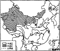
【1】我国年降水量分布的总趋势是
A. 从东北向西南递减 B. 从西北内陆向东南沿海递减
C. 从西南向东北递减 D. 从东南沿海向西北内陆递减
【2】我国的内流河主要分布在
A. 东南部 B. 西北部 C. 西南部 D. 东北部
【3】下列河流中,汛期最长的是
A. 松花江 B. 黄河 C. 长江 D. 西江
【4】“黄河之水天上来,奔流到海不复回”,这里的“天上”和“海”分别是指
A. 唐古拉山、东海 B. 祁连山、黄海 C. 巴颜喀拉山、渤海 D. 青藏高原、南海
【5】“地上河”形成于黄河的 河段
A. 源头 B. 上游 C. 中游 D. 下游
【6】黄河是世界上含沙量最大的河流,泥沙主要来自于
A. 黄土高原 B. 内蒙古高原 C. 青藏高原 D. 华北平原
查看答案和解析>>
科目: 来源: 题型:
【题目】抛物线y=ax2+bx+c上部分点的横坐标x、纵坐标y的对应值如下表:
x | … | -2 | -1 | 0 | 1 | 2 | … |
y | … | 0 | 4 | 6 | 6 | 4 | … |
从上表可知,下列说法中正确的是___________ (填写序号).
①抛物线与x轴的一个交点为(3,0);②函数y=ax2+bx+c的最大值为6;③抛物线的对称轴是x=0.5;④在对称轴左侧,y随x的增大而增大.
查看答案和解析>>
科目: 来源: 题型:
【题目】读中国略图,联系所学内容,回答下面小题。
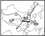
【1】我国人口地理分界线是图中的 线
A. ① B. ② C. ③ D. ④
【2】地势第二级阶梯和第三级阶梯的界线是图中的 线
A. ① B. ② C. ③ D. ④
【3】秦岭——淮河一线大致经过图中的 线
A. ① B. ② C. ③ D. ④
【4】南京位于我国温度带中的
A. 热带 B. 亚热带 C. 暖温带 D. 中温带
【5】拉萨比西安的纬度低,但夏季气温明显低于西安,主要影响的因素是
A. 地形因素 B. 海陆因素 C. 纬度因素 D. 冬季风
【6】我国人口分布的特点是
A. 全国分布比较均匀 B. 东部多,西部少
C. 西北多,东南少 D. 西部多,东部少
【7】下列关于秦岭——淮河一线地理意义的描述,正确的是
A. 是我国0℃等温线通过的地方 B. 该线以北河流没有结冰期
C. 该线以南是我国的半湿润地区 D. 是我国800mm年等降水量线通过的地方
查看答案和解析>>
湖北省互联网违法和不良信息举报平台 | 网上有害信息举报专区 | 电信诈骗举报专区 | 涉历史虚无主义有害信息举报专区 | 涉企侵权举报专区
违法和不良信息举报电话:027-86699610 举报邮箱:58377363@163.com