科目: 来源: 题型:
【题目】下列农业生产方式中,比较合理的是( )
A. 西部半干旱地区退林种粮B. 新疆地区河流沿岸种植棉花
C. 华北平原大面积种植水稻D. 长江中下游地区围湖造田
查看答案和解析>>
科目: 来源: 题型:
【题目】2017年5月,来自“一带一路”沿线的20国青年评选出了中国的“新四大发明”:高铁、扫码支付、共亨单车和网购。下图均为某共享单车APP(应用软件)的使用界面,据此回答下面小小题。
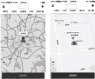
【1】此共享单车APP(应用软件)界面显示的地图属于( )
A. 地形图 B. 亚洲地图 C. 遥感地图 D. 电子地图
【2】比较两图,分析正确的是( )
A. 左图比例尺更大 B. 右图显示内容详细
C. 左图更便于寻找共享单车 D. 右图显示范围更广
查看答案和解析>>
科目: 来源: 题型:
【题目】地理兴趣小组对某小流域进行水土流失的调查。在调查之前,该组同学需要优先收集调查区的地形图和( )
A. 气温分布图 B. 降水量分布图 C. 工业分布图 D. 旅游景点分布图
查看答案和解析>>
科目: 来源: 题型:
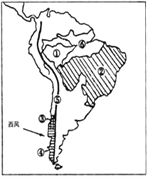
【题目】读“南亚地区农作物分布图”,完成下面小题。

【1】据图可知,有关南亚农作物分布的叙述,正确的是( )
A. 棉花分布在东北部地区
B. 小麦分布在恒河三角洲
C. 水稻分布在东北部和西部沿海
D. 黄麻分布在印度河平原
【2】图中四城市中,最适合发展棉纺织工业的是( )
A. ① B. ② C. ③ D. ④
查看答案和解析>>
科目: 来源: 题型:
【题目】Jilin is a good place. It is in the north-east of China. On the north of it is Heilongjiang, the south is Liaoning, the west is Inner Mongolia and the east is North Korea(朝鲜).
It has a long and snowy winter. Usually the winter here starts from October and lasts(持续) for six months. Every year people come here for the Ice Lantern Festival and the winter sports.
Changbai Shan is the first mountain in the north-east of China. There is a lot of snow on the main mountain-"Baitou Shan" all the year, so it is named "C. hangbai Shan". It has great forests on it. There are tigers, deer, black bears and many other animals in the forests and there are a lot of hot springs (泉) and more than l,500 kinds of plants. On the very top of the mountain is Tianchi. If you come to the lake, you might see the monster(水怪) in it.
There is also a great waterfall(瀑布) where the Songhua River comes from.
Another place in Jilin is Xianghai in Tongyu County(县). There are more than 100 pieces of wetlands here. And they are of different sizes. There are 170 kinds of birds, some fish that we can't often see and over 250 different herbal(草药) plants and trees here.
【1】Which is the right map?


A. B. C. D.
【2】Winter in Jilin is from _______ to _______.
A. January; April B. September; December C. October; April D. November; May
【3】Which of the following is true?
A. Because of the snow on the top of the main mountain, people named it Changbai Shan.
B. There are tigers, bears and other animals in the hot spring.
C. Tianchi is a lake in the forest at the foot of the mountain.
D. Songhua River comes from the lake of the mountain.
【4】What can we see in the wetland in Tongyu County?
A. Different kinds of birds. B. All kinds of fish. C. Huge monsters. D. North-east tigers.
【5】The writer doesn't tell us _______ in the passage.
A. the neighbors of Jilin B. the temperature in winter in Jilin
C. the famous mountain in Jilin D. where there are herbal plants in Jilin
查看答案和解析>>
科目: 来源: 题型:
【题目】读下图,完成下列问题.

(1)我国的四大海产是 、小黄鱼、 、乌贼.
(2)图中A,B,C是我国主要盐场的示意.其中,我国 目前最大的盐场是(填字母),该盐场位于 海西岸;位于台湾岛的盐场是 (填字母).相对于南方地区的盐场,北方的盐场雨季 (长、短),更有利晒制海盐.
(3)我国最大的渔场是位于海的渔场 .
(4)对我国近海鱼类丰富的原因分析,不正确的是
A.地跨热带、亚热带、温带,适宜多种海洋生物生长 B.海水深,有利于鱼类活动
C.寒暖流交汇,各种鱼类云集 D.众多河流汇入,饵料丰富
(5)目前,我国合理开发和利用海洋资源,应该采取的措施是
A.限制沿海地区海盐的生产 B.限制海洋养殖业的发展
C.禁止过度捕捞海洋生物资源,努力做到捕养结合
D.禁止海上石油开采,以免产生石油污染
查看答案和解析>>
科目: 来源: 题型:
【题目】读图回答下列问题。
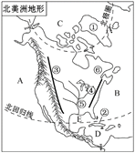
(1)北美洲地形分为_____________,西部为高大的_____________山系,中部为广阔的_________,东部为低缓的高原和山地。
(2)南美洲有世界上水量最大的___________河,该河水量大的原因是__________,_________。(从地形、气候方面分析)
查看答案和解析>>
湖北省互联网违法和不良信息举报平台 | 网上有害信息举报专区 | 电信诈骗举报专区 | 涉历史虚无主义有害信息举报专区 | 涉企侵权举报专区
违法和不良信息举报电话:027-86699610 举报邮箱:58377363@163.com