【题目】我国海南省、广东省雷州半岛所属的农业生产地域类型是
A.地中海型农业B.高度发达的商品化混合农业
C.热带种植园农业D.传统旱作农业
科目:高中地理 来源: 题型:
【题目】下图是江苏某科技产业园规划示意图。该科技产业园规划面积40平方千米。读图回答下列问题。
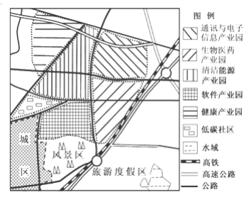
(1)该科技产业园的区位优势有( )。
①靠近原料产地②邻近城区市场③生态环境优美④对外交通便捷
A.①②B.②③C.③④D.①④
(2)该科技产业园对当地的影响主要有( )。
①促进产业升级 ②减轻交通压力③缓解用地紧张 ④增加就业机会
A.①②B.②③C.③④D.①④
查看答案和解析>>
科目:高中地理 来源: 题型:
【题目】马拉维湖位于东非大裂谷最南端,是非洲第三大淡水湖,四周有众多河流注入。马拉维湖湖水的透明度因温度和降水的影响,随季节的变化较为剧烈,12月份透明度不足1米。马拉维湖湖中生物种类十分丰富,仅慈鲷鱼就有850多种。慈鲷鱼都生活在湖底,且只有沿湖岸线的狭窄区域才有分布。读马拉维湖及周边地区示意图,完成下列各题。

【1】马拉维湖的形成原因是( )
A. 地壳断裂下陷 B. 河流改道
C. 褶皱凹陷 D. 冰川作用
【2】马拉维湖12月份透明度低的主要原因可能是( )
A. 降水量丰富,入湖水量大 B. 风力弱,湖水流动性差
C. 气温高,蒸发旺盛 D. 太阳高度角小
【3】慈鲷鱼只分布于沿湖岸线的狭窄区域,主要是由于( )
A. 河流入湖带来丰富的营养物质
B. 湖岸沿线水域较浅,阳光和氧气充足
C. 湖岸沿线水质好
D. 底层湖水上涌,饵料丰富
查看答案和解析>>
科目:高中地理 来源: 题型:
【题目】巴西是南美洲面积最大、人口最多、经济最发达的国家,属于新兴经济“金砖五国”之一,读下图,回答下面小题。
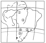
【1】关于图中①②③④表示的地理事物,叙述正确的是( )
A. ①河是世界上流程最长的河流 B. ②城市是巴西最大的城市
C. ③水电站是目前世界上最大的水电站 D. ④高原地区属于热带雨林气候
【2】关于巴西经济和人口的叙述,正确的是( )
A. 已形成较完整的工业体系 B. 世界上最大的可可生产国和出口国
C. 亚马孙平原地势低平,人口稠密 D. 人种复杂,城市人口比重低
查看答案和解析>>
科目:高中地理 来源: 题型:
【题目】Facebook users may feel socially successful in cyberspace(虚拟空间) but they are more likely to perform poorly in exams,according to a new research into the academic impact of the social networking website.

About 83% of British 16 to 24yearolds are thought to use social networking sites such as Facebook,MySpace and Bebo(视频博客),to keep in touch with friends and organize their social lives.
“Our study shows people who spend more time on Facebook spend less time studying,”said Aryn Karpinski,a researcher in the education department at Ohio State University.“Every generation has its distractions,but I think Facebook is a unique phenomenon.”
Karpinski and a colleague questioned 219 US undergraduates and graduates about their study practices and general Internet use,as well as their specific use of Facebook.
They found that 65% of Facebook users accessed their account daily(刷新个人主页),usually checking it several times to see if they had received new messages.The amount of time spent on Facebook at each login varied from just a few minutes to more than an hour.
The Ohio report shows that students who used Facebook had a“significantly”lower grade point average—the marking system used in US universities—than those who did not use the site.
“It is the equivalent of the difference between getting an A and a B,”said Karpinski,who will present her findings this week to the annual meeting of the American Educational Research Association.
Some UK students have already spotted the potential danger.Daisy Jones,21,an undergraduate in her final year at Loughborough University,realized the time she was spending on Facebook was threatening her grades—prompting her to deactivate(注销) her account.
Jones is among the few to have recognized the risks.According to Karpinski's research,79% of Facebookusing students believed the time they spent on the site had no impact on their work.
Facebook said,“There is also academic research that shows the benefits of services like Facebook.It's in the hands of students,in consultation with their parents,to decide how to spend their time. ”
【1】According to the passage we know that most present students like to get in touch with their friends by ________.
A. sending short messages B. chatting online
C. Facebook site D. sending emails
【2】The study shows that compared to ones who avoid websites,the school results of the students who use social networking sites are ________.
A. the equivalent of the difference between getting an A and a B
B. not less grades in all studies
C. more ambitious to succeed in their studies
D. just the same
【3】Researchers' survey aimed at students on the following EXCEPT ________.
A. their study practices
B. their general Internet use
C. their specific use of Facebook
D. their habits of living
【4】In your opinion,this research result will appear as ________.
A. news B. text
C. report D. essay
查看答案和解析>>
科目:高中地理 来源: 题型:
【题目】西非大多数人口从事农业生产活动,马里是西非的一个内陆国家,人口1 630万。读马里地区图及巴马科降水月分配图,回答下面小题。
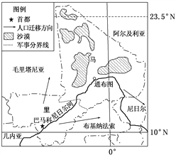

【1】巴马科最高月均温出现在( )
A. 3月 B. 4月 C. 6月 D. 7月
【2】造成图中马里人口大量外迁的主要原因是( )
A. 周边国家第三产业发达 B. 周边国家水源更充足
C. 周边国家气候相对温和 D. 周边国家局势安定
查看答案和解析>>
科目:高中地理 来源: 题型:
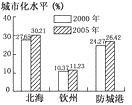
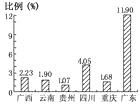
【题目】北海、钦州、防城港是北部湾经济区重要的港口城市。根据下列资料,结合所学知识,回答相关问题。
资料1:北海、钦州、防城港位置示意图。
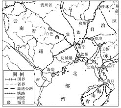
资料2:北海、钦州、防城港2000~2004年三次产业产值表。
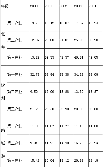
材料3:北海、钦州和防城港城市化水平图。
材料4:2005年六省(市、区)GDP各占全国比例图。
(1)关于三城市2000~2004年的三次产业产值变化,下列叙述错误的是( )(单选题,填选项字母)。
A.北海市第一产业产值逐年下降B.防城港市第二产业产值逐年上升
C.钦州市第三产业产值逐年上升 D.第三产业产值上升最快的是北海市
(2)分析北海、钦州和防城港三港口发展中遇到的共同问题。
(3)提出北部湾经济区港口群的发展对策。
查看答案和解析>>
科目:高中地理 来源: 题型:
【题目】刚刚闭幕的第三届联合国环境大会上,中国表现抢眼。塞罕坝林场建设者获得2017年联合国环保最高荣誉——“地球卫士奖”,中国摩拜单车公司获得“商界卓识奖’。下图为塞罕坝林场位置示意图。据此完成下面小题。
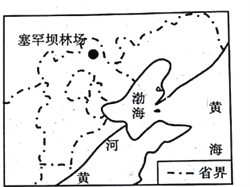
【1】从1962年至今,赛罕坝林场培育出112万亩人工林,成为“生态文明建设范例”。下列关于该林场表述正确的是
A. 选择常绿硬叶林为主要营林品种 B. 对东北地区生态安全的意义重大
C. 春季防火等级最高 D. 经过50多年的营林,成为重要的木材基地
【2】下列关于塞罕坝林场产生的影响,描述正确的是
A. 对东北林区的开发提供了借鉴意义 B. 保护华北地区生态环境,防风固沙
C. 减少黄土高原水土流失 D. 防止内蒙古中部草原退化
查看答案和解析>>
科目:高中地理 来源: 题型:
【题目】读“美国农业分布图”,完成下列问题。

【1】图中①附近工农业生产的主要类型是
A. 传统工业和乳畜业。 B. 高技术产业和商品谷物农业
C. 新兴工业和水稻种植业 D. 分散型工业和密集型农业?
【2】图中带标号的四个地区,主要粮食作物和农业地域类型与我国松嫩平原大体相同的是
A. ① B. ② C. ③ D. ④
查看答案和解析>>
湖北省互联网违法和不良信息举报平台 | 网上有害信息举报专区 | 电信诈骗举报专区 | 涉历史虚无主义有害信息举报专区 | 涉企侵权举报专区
违法和不良信息举报电话:027-86699610 举报邮箱:58377363@163.com
