【题目】每年5-10月,柬埔寨洞里萨湖面积达10000平方千米,平均水深10米;而11月~次年4月,面积不足3000平方千米,平均水深仅1米。读湄公河流域图,完成下列各题。

【1】洞里萨湖水量季节变化显著的主要原因是
A.水稻种植业用水量的季节变化
B.季风导致降水量的季节变化
C.台风引起风暴潮导致海水倒灌
D.北部高原夏季冰雪大量消融
【2】20世纪80年代以来,柬埔寨及周边邻国成为世界电子工业投资的热点区域,其原因主要是该地区
A.科技力量强大 B.铁路交通便利
C.劳动者素质高 D.国家政策扶持
 快乐小博士巩固与提高系列答案
科目:高中地理 来源: 题型:
【题目】阅读图文材料,回答下列问题。
下图中的D是世界上海拔最高的淡水湖,湖面有周期性的涨落。图示区域是南美洲印第安人文化的发源地之一,现人口密度较小。D湖周围的耕地是世界上海拔最高的耕地,居民种植作物,大都将作物当做饲料从事动物饲养。有人建议,为利用该区域的草场资源,引进来自中国青藏高原的牦牛发展放牧业。右图是湖区的降水统计资料。

(1)指出湖水周期性涨落的规律并解释原因。
(2)用水循环原理解释D湖泊为淡水湖的原因。
(3)分析湖区周围的农业偏向于动物饲养的主要原因。
(4)你认为该区域引进牦牛发展畜牧业的建议是否可行?请简述理由。
查看答案和解析>>
科目:高中地理 来源: 题型:
【题目】阅读材料,回答下列问题。
材料一 2014年1月14日,国家林业局三北局在银川召开2014年三北防护林站局长会议。会议总结了2013年三北工程建设进展情况,分析工程建设面临的形势和任务,安排部署2014年重点工作。建设历时34年(1978~2012年)的三北防护林体系经过四期工程,已累计完成造林保存面积2 647万公顷,其中,营造防风固沙林282.4万公顷,各类经济林369万公顷,薪炭林107万公顷,营造灌木饲料500多万公顷,工程区森林覆盖率由1997年的5.05%提高到12.4%。三北工程取得了生态环境改善、经济效益良好、社会效益突出的显著成就。
材料二 我国生态工程分布示意图。

(1)图中字母B表示的是我国的三北防护林工程,试根据材料总结其主要作用。
(2)A地区的森林覆盖率急剧下降,针对此状况你认为应该采取何种措施?
(3)在长江中下游低山丘陵区植树造林,对长江径流量和长江水质有什么影响?
查看答案和解析>>
科目:高中地理 来源: 题型:
【题目】A sign is another kind of language. Here are some of them that you see on the roads.

Number one is a sign with the number thirty on it.When drivers see this sign, they must not go at more than thirty kilometres an hour. We see this sign when we are getting near a town.Number two is a sign that we’re near a crossing.We must drive carefully.Number three is a sign that there is a bend in the road.Again, we must drive slowly and carefully.It is not safe to go round a bend very fast.Number four is a sign that there is another road coming in from the right.There is a junction at this place. Number five is a sign that there is a hill and number six is a sign that the road gets narrow. Drivers must go slowly and carefully.Number seven has the word “SCHOOL” on it. This is a sign that there is a school at the side of the street or the road. Perhaps there are children going to or leaving school.So drivers must look carefully and go slowly. Number eight is a sign with the letter “P” on it.The letter “P”means “Parking”. At some places, there’re the signs “No parking””or “No waiting”. If a driver leaves his car near one of these signs, a policeman may come and write down the number of his car.
【1】At the places where you see Sign 1, ________.
A. you are already out of a town
B. you still have thirty kilometres to go
C. there must be a town thirty kilometres away
D. there must be many houses and buildings not far away
【2】There stands Sign 2 near a place where________.
A. two roads cross B. people can cross the road
C. the roads get narrow D. there are no traffic lights
【3】You have to drive not only slowly but also carefully when you find________.
A. each of the eight signs B. either of Signs 2 and 3
C. all of Signs 3, 5, 6 and 7 D. any of Signs 3, 5, 6 and 7
【4】A driver can leave his car________.
A. near Sign 8 at any time
B. near a sign with “No parking” on it
C. near a sign with “No waiting” if there’re no police there
D. near a sign with “P” on it in the daytime
【5】People put these signs on the roads to________.
A. show drivers the way B. stop cars going too fast
C. make driving even safer D. learn another kind of language
查看答案和解析>>
科目:高中地理 来源: 题型:
【题目】读德国鲁尔区和我国辽中南工业基地图,完成下面小题。

【1】两地发展钢铁工业相同的区位优势是( )
①接近煤炭产地 ②水源充沛 ③水陆交通便利 ④市场广阔 ⑤廉价劳动力多
A. ①③④ B. ③④⑤ C. ①③⑤ D. ①④⑤
【2】德国鲁尔区衰落最为明显的工业部门是( )
A. 机械工业 B. 电力工业 C. 化学工业 D. 煤炭工业
查看答案和解析>>
科目:高中地理 来源: 题型:
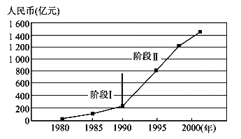
【题目】读珠江三角洲工业总产值增长图,回答下面小题。

【1】以下属于阶段Ⅰ工业发展特点的是( )
A. 建立了大批日用消费品加工工厂 B. 外商的投资规模相对较大
C. 工业附加值增长较快 D. 成为我国最大电子信息产业基地
【2】以下不属于珠江三角洲地区在阶段Ⅱ进行产业升级的原因的是( )
A. 全国对外开放范围的扩大 B. 新能源矿产基地的开发
C. 劳动成本优势的逐步丧失 D. 发达国家和地区新一轮产业结构的调整
查看答案和解析>>
科目:高中地理 来源: 题型:
【题目】下图为三个区域的人口统计图。读图回答下面小题。

【1】a、b区域的人口再生产类型分别属于 ( )
A. 现代型和过渡型 B. 原始型和传统型 C. 现代型和传统型 D. 传统型和过渡型
【2】影响c区域人口自然增长率的主要因素有 ( )
①经济发展水平较高 ②人口受教育水平较低 ③医疗卫生水平较低 ④人们的生育意愿较低
A. ①② B. ①④ C. ②③ D. ③④
查看答案和解析>>
科目:高中地理 来源: 题型:
【题目】读世界范围内某地区的传统民居和当地气候资料图,完成下列各题。


【1】当地传统民居为木质角楼的主要原因是
A. 冬季寒冷,木质结构利于保温 B. 避免地质灾害的侵袭
C. 气候湿热,有利于通风散热 D. 为了顺应地形地势
【2】该地可能位于
A. 东非高原 B. 云贵高原 C. 伊朗高原 D. 圭亚那高原
查看答案和解析>>
科目:高中地理 来源: 题型:
【题目】经对武广线与京沪线的研究表明,一般城市规模越小,高铁站距离城市中心相对也越远。距城市中心最远的枣庄站和宿州东站与城市中心的距离甚至达到30km。边缘城市的边缘车站是否能带来足够的人流量和关注度,实际上颇为可疑。读图表,完成下列问题。

【1】高铁运输枢纽与城市的空间关系主要取决于
A. 高铁到城市的距离 B. 城市的等级规律
C. 城市的空间结构 D. 城市的地域类型
【2】根据图表分析,高铁站属于城市中心型的有
A. 小城市、中等城市 B. 大城市、特大城市
C. 中等城市、大城市 D. 超大城市、特大城市
【3】机场飞地型高铁站形成的新城区
A. 拉动了地铁等城市基础设施建设 B. 降低了旅客的出行成本
C. 有利于缓解中心城市的“城市病” D. 扩大了城市的等级规模
查看答案和解析>>
湖北省互联网违法和不良信息举报平台 | 网上有害信息举报专区 | 电信诈骗举报专区 | 涉历史虚无主义有害信息举报专区 | 涉企侵权举报专区
违法和不良信息举报电话:027-86699610 举报邮箱:58377363@163.com