【题目】下图是沿我国境内某一经线的地形剖面、气候统计图。读图,完成下题。
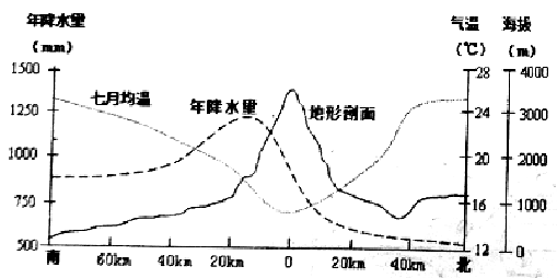
【1】下列有关图中山岭的说法正确的是
A.是我国第二级阶梯和第三级阶梯的分界线
B.该山脉大体呈南北走向
C.与400毫米等降水量线大致吻合
D.是亚热带和暖温带、湿润区和半湿润区的分界线
【2】图中降水最多的地点,其海拔约为
A.900m B.1500m C.2000m D.3000m
科目:高中地理 来源: 题型:
【题目】下列物质能使干燥的蓝色石蕊试纸先变红后褪色的是( )
①氯气 ②液氯 ③新制的氯水 ④氯气的酒精溶液
⑤盐酸 ⑥盐酸酸化的漂白粉溶液
A.①②③ B.①②③⑥
C.③⑥ D.②③⑥
查看答案和解析>>
科目:高中地理 来源: 题型:
【题目】硅及其化合物在材料领域中应用广泛。下列说法正确的是( )
A.光导纤维的主要成分是硅 B.水晶项链的主要成分是硅酸盐
C.晶体硅能用来制造太阳能电池 D.二氧化硅是一种半导体材料
查看答案和解析>>
科目:高中地理 来源: 题型:
【题目】下表为我国部分城市住宅的日照间距,完成下列各题。
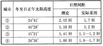
【1】
A. ① B. ② C. ③ D. ④
【2】
A. 由南向北逐渐缩小 B. 由南向北逐渐扩大
C. 由西向东逐渐缩小 D. 由西向东逐渐扩大
查看答案和解析>>
科目:高中地理 来源: 题型:
【题目】下图为海河水系和水利示意图。回答下题。
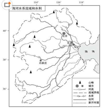
【1】划分海河流域范围的依据最可能是
A.降水量 B.地形 C.人口密度 D.行政区划
【2】20世纪中叶以来,流域内出现众多水库,这些水库的作用主要有
①保障城乡用水 ②有利于进行有效的防洪调度
③实现水能开发,提供充足的电力供应 ④减缓干旱带来的不利影响
⑤大坝拦截泥沙,防治水土流失 ⑥提高河道的通航能力
A. ①②④ B. ①③⑤ C. ②⑤⑥ D. ③④⑥
查看答案和解析>>
科目:高中地理 来源: 题型:
【题目】C
The production of coffee beans is a huge, profitable business, but, unfortunately, full-sun production is taking over the industry and bringing about a lot of damage. The change in how coffee is grown from shade-grown production to full-sun production endangers the very existence of certain animals and birds, and even disturbs the world’s ecological balance.
On a local level, the damage of the forest required by full-sun fields affects the area’s birds and animals. The shade of the forest trees provides a home for birds and other species(物种)that depend on the trees’ flowers and fruits. Full-sun coffee growers destroy this forest home. As a result, many species are quickly dying out.
On a more global level, the destruction of the rainforest for full-sun coffee fields also threatens(威胁)human life. Medical research often makes use of the forests’ plant and animal life, and the destruction of such species could prevent researchers from finding cures for certain diseases. In addition, new coffee-growing techniques are poisoning the water locally, and eventually the world’s groundwater.
Both locally and globally, the continued spread of full-sun coffee plantations(种植园)could mean the destruction of the rainforest ecology. The loss of shade trees is already causing a slight change in the world’s climate, and studies show that the loss of oxygen-giving trees also leads to air pollution and global warming. Moreover, the new growing techniques are contributing to acidic(酸性的)soil conditions.
It is obvious that the way much coffee is grown affects many aspects of life, from the local environment to the global ecology. But consumers do have a choice. They can purchase shade-grown coffee whenever possible, although at a higher cost. The future health of the planet and mankind is surely worth more than an inexpensive cup of coffee.
【1】What can we learn about full-sun coffee production from Paragraph 4?
A. It limits the spread of new growing techniques.
B. It leads to air pollution and global warming.
C. It slows down the loss of shade trees.
D. It improves local soil conditions.
【2】The purpose of the text is to .
A. entertain B. advertise
C. instruct D. persuade
【3】Where does this text probably come from?
A. An agricultural magazine. B. A medical journal.
C. An engineering textbook. D. A tourist guide.
【4】Which of the following shows the structure of the whole text?
查看答案和解析>>
科目:高中地理 来源: 题型:
【题目】Hot ___the night air was,we slept deeply because we were so tired after the long journey
A.although
B.as
C.while
D.however
查看答案和解析>>
科目:高中地理 来源: 题型:
【题目】雾凇,俗称树挂,是在严寒季节里,空气中过于饱和的水汽遇冷凝华而成。2015年12月23日在京密路沿线出现了难得一见的雾凇景观。下图为某网友拍摄的雾凇景观照片。读图,回答下列各题。
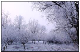
【1】利于雾凇形成的主要条件有
①水汽充足 ②风速较大 ③天晴少云 ④日温差小
A.①② B.①③ C.②④ D.③④
【2】观赏该景观的最佳时间是
A.早晨 B.中午 C.下午 D.傍晚
查看答案和解析>>
科目:高中地理 来源: 题型:
【题目】读构想中的兰(州)厦(门)铁路及沿线地区图,回答下列各题。
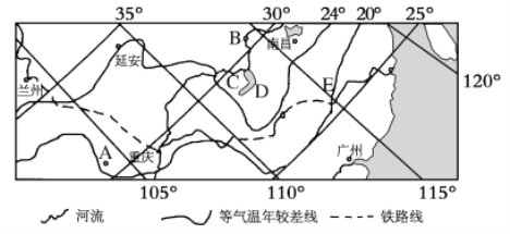
【1】自东向西与兰厦铁路相交的南北向铁路干线依次是( )
A.焦柳线——陇海线——京广线——京九线
B.浙赣线——京广线——京九线——宝成线
C.宝成线——焦柳线——京广线——京九线
D.京九线——京广线——焦柳线——宝成线
【2】图示A、B、C、D四地描述正确的是( )
A.A地位于秦巴山地,气温年较差大
B.B地位于四川盆地,气温年较差小
C.C地区部分河段形成地上河
D.D是我国最大的淡水湖
【3】E地区农业资源综合开发中突出的生态问题是( )
A.土地次生盐碱化 B.水土流失严重
C.土地石漠化 D.土地沙化
查看答案和解析>>
湖北省互联网违法和不良信息举报平台 | 网上有害信息举报专区 | 电信诈骗举报专区 | 涉历史虚无主义有害信息举报专区 | 涉企侵权举报专区
违法和不良信息举报电话:027-86699610 举报邮箱:58377363@163.com
